
June 2006 at Lerwick
This event was part of a 10-day low ozone anomaly that started over the Eastern North Atlantic. It was then blocked and quasi-stationary for nearly a week near Lerwick. This episode was associated with a tropospheric anticyclone advecting warm air from the south and lifting the tropopause thus reducing the ozone column locally.
Figure A shows the anomaly and spatial extent of this event as seen by the satellite OMI.
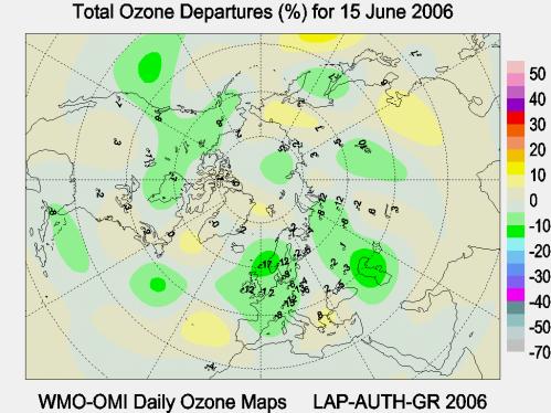
Figure A: The anomaly of ozone expressed as a percentage of the long term mean for the 15th of June
This event was part of a 10-day low ozone anomaly that started over the Eastern North Atlantic. It was then blocked and quasi-stationary for nearly a week near Lerwick. This episode was associated with a tropospheric anticyclone advecting warm air from the south and lifting the tropopause thus reducing the ozone column locally.
Figure A shows the anomaly and spatial extent of this event as seen by the satellite OMI.
Figure A: The anomaly of ozone expressed as a percentage of the long term mean for the 15th of June