
Site Information for Narberth(UKA00323)
Narberth Information
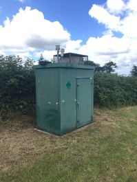
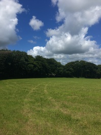
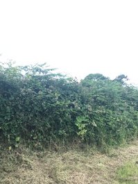
The monitoring station is within a self-contained, air conditioned housing located at the edge of a field adjacent to a hedgerow. A quiet rural road runs to the west of the site at a distance of approximately 150 metres. The nearest main road is the B4314 at a distance of 100 metres from the site. The manifold inlet is approximately 5 metres from the nearest obstruction. The surrounding area is open and comprises fields with a small amount of light industry and farming at distances of up to 0.5 - 1.8 kilometres distance.
UK-AIR ID: UKA00323
EU Site ID: GB0043R
Altitude (metres): 160
Environment Type: Rural Background
Site Location
Environment Type: Rural Background
Site Address: Narberth
Government Region: South Wales
Easting/Northing: 214381, 212758
Latitude/Longitude: 51.782616, -4.692370
The static map below shows where the monitoring site is located.
» View this location on Google Maps (new window)
» View this monitoring site on the interactive monitoring networks map
Partners
The Partners who operate networks at this monitoring sites are shown in the table below. Clicking on the Partner name will open their website in a new window.
| Operator | Networks |
|---|---|
| Centre for Ecology & Hydrology | Acid Gas and Aerosol Network |
| Centre for Ecology & Hydrology | National Ammonia Monitoring Network |
| Bureau Veritas | Automatic Rural Monitoring Network |
Pollutants measured at this monitoring site
The pollutants measured at this monitoring site, grouped by network, are shown below. Use the links below to quickly jump to a specific network.
Acid Gas and Aerosol Network
| Pollutant | Start Date | End Date | Inlet Height (m) |
|---|---|---|---|
| Particulate calcium | 15/03/2006 | - | 1.5 |
| Particulate chloride | 15/03/2006 | - | 1.5 |
| Particulate magnesium | 15/03/2006 | - | 1.5 |
| Particulate sodium | 15/03/2006 | - | 1.5 |
| Particulate nitrite | 26/06/2009 | - | 1.5 |
| Particulate nitrate | 15/03/2006 | - | 1.5 |
| Particulate sulphate | 15/03/2006 | - | 1.5 |
| Gaseous hydrochloric acid | 15/03/2006 | 04/01/2016 | 1.5 |
| Gaseous nitric acid | 15/03/2006 | - | 1.5 |
| Gaseous nitrous acid | 26/06/2009 | - | 1.5 |
| Gaseous sulphur dioxide | 15/03/2006 | - | 1.5 |
Automatic Rural Monitoring Network
| Pollutant | Start Date | End Date | Inlet Height (m) | Hourly PM Measurement method |
|---|---|---|---|---|
| Ozone | 20/01/1997 | - | 2.6 | |
| Nitric oxide | 20/01/1997 | - | 2.6 | |
| Nitrogen dioxide | 20/01/1997 | - | 2.6 | |
| Nitrogen oxides as nitrogen dioxide | 20/01/1997 | - | 2.6 | |
| Sulphur dioxide | 20/01/1997 | - | 2.6 | |
| PM10 particulate matter (Hourly measured) | 20/01/1997 | - | 2.6 | FIDAS |
| Non-volatile PM10 (Hourly measured) | 16/03/2009 | 07/06/2018 | Not available | FDMS |
| Volatile PM10 (Hourly measured) | 16/03/2009 | 07/06/2018 | Not available | FDMS |
| PM2.5 particulate matter (Hourly measured) | 05/06/2018 | - | 2.6 | FIDAS |
| Modelled Wind Direction | 01/08/2010 | - | 10 | |
| Modelled Wind Speed | 01/08/2010 | - | 10 | |
| Modelled Temperature | 01/08/2010 | - | 2 |
National Ammonia Monitoring Network
| Pollutant | Start Date | End Date | Inlet Height (m) |
|---|---|---|---|
| particulate ammonium | 15/03/2006 | - | 1.5 |
| gaseous ammonia (active) | 15/03/2006 | - | 1.5 |
| gaseous ammonia (passive) | 01/01/2022 | - | 2.3 |
Networks measured at this monitoring site
The listing below shows the networks that this monitoring site belongs to. You can search for sites within these networks by clicking on their name, or use the network information links to find out more about them.
| Network | Search | Further Details | Get Data |
|---|---|---|---|
| Automatic Urban and Rural Monitoring Network (AURN) | Automatic Urban and Rural Monitoring Network (AURN) | About network | Latest pollution summary Current Levels Pre-Formatted Data Files |
| UKEAP: Acid Gases & Aerosol Network | UKEAP: Acid Gases & Aerosol Network | About network | CEH Website (External website) Data Selector |
| UKEAP: National Ammonia Monitoring Network | UKEAP: National Ammonia Monitoring Network | About network | Data Selector |