
Site Information for Strathvaich(UKA00162)
Strathvaich Information
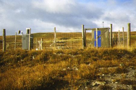
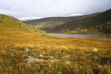
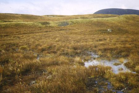
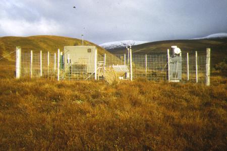
The monitoring station is within a self-contained, air conditioned housing located on remote moorland approximately 500 metres from the nearest inhabited dwellings. The nearest road is approximately 150 metres from the site and used for access only. The surrounding area is open and remote. The site is at the SE corner of a large body of open water - Loch Vaich.
UK-AIR ID: UKA00162
EU Site ID: GB0015R
Altitude (metres): 270
Environment Type: Rural Background
Site Location
Environment Type: Rural Background
Site Address: Strath Vaich
Government Region: Highland
Easting/Northing: 234787, 875023
Latitude/Longitude: 57.734456, -4.776583

The static map below shows where the monitoring site is located.
» View this location on Google Maps (new window)
» View this monitoring site on the interactive monitoring networks map
Partners
The Partners who operate networks at this monitoring sites are shown in the table below. Clicking on the Partner name will open their website in a new window.
| Operator | Networks |
|---|---|
| Bureau Veritas | Automatic Rural Monitoring Network |
Pollutants measured at this monitoring site
The pollutants measured at this monitoring site, grouped by network, are shown below. Use the links below to quickly jump to a specific network.
- Acid Gas and Aerosol Network
- Automatic Rural Monitoring Network
- Daily Rainfall Bulk
- Daily rainfall WOC
- National Ammonia Monitoring Network
- Other AP system network
- UKEAP - Rural NO2 (NO2-Net)
- UKEAP - Rural NO2 (NO2-Net) - parallel sampling
- Weekly Rainfall (HIGH)
Acid Gas and Aerosol Network
| Pollutant | Start Date | End Date | Inlet Height (m) |
|---|---|---|---|
| Particulate calcium | 08/09/1999 | - | 1.5 |
| Particulate chloride | 08/09/1999 | - | 1.5 |
| Particulate magnesium | 08/09/1999 | - | 1.5 |
| Particulate sodium | 08/09/1999 | - | 1.5 |
| Particulate nitrite | 08/09/1999 | - | 1.5 |
| Particulate nitrate | 08/09/1999 | - | 1.5 |
| Particulate sulphate | 08/09/1999 | - | 1.5 |
| Gaseous hydrochloric acid | 08/09/1999 | 01/01/2016 | 1.5 |
| Gaseous nitric acid | 08/09/1999 | - | 1.5 |
| Gaseous nitrous acid | 08/09/1999 | - | 1.5 |
| Gaseous sulphur dioxide | 08/09/1999 | - | 1.5 |
Automatic Rural Monitoring Network
| Pollutant | Start Date | End Date | Inlet Height (m) | Hourly PM Measurement method |
|---|---|---|---|---|
| Ozone | 18/03/1987 | - | 4.0 | |
| Nitric oxide | 21/10/1990 | 14/03/1997 | Not available | |
| Nitrogen dioxide | 21/10/1990 | 14/03/1997 | Not available | |
| Nitrogen oxides as nitrogen dioxide | 21/10/1990 | 14/03/1997 | Not available | |
| Sulphur dioxide | 20/10/1990 | 14/03/1997 | Not available | |
| Modelled Wind Direction | 01/08/2010 | - | 10.0 | |
| Modelled Wind Speed | 01/08/2010 | - | 10.0 | |
| Modelled Temperature | 01/08/2010 | - | 2.0 |
Daily Rainfall Bulk
| Pollutant | Start Date | End Date | Inlet Height (m) |
|---|---|---|---|
| Calcium in precipitation | 01/01/1997 | 27/03/1998 | Not available |
| Chloride in precipitation | 01/01/1997 | 27/03/1998 | Not available |
| Potassium in precipitation | 01/01/1997 | 27/03/1998 | Not available |
| Magnesium in precipitation | 01/01/1997 | 27/03/1998 | Not available |
| Sodium in precipitation | 01/01/1997 | 27/03/1998 | Not available |
| Phosphate as P in precipitation | 01/01/1997 | 27/03/1998 | Not available |
| Nitrate as N in precipitation | 01/01/1997 | 27/03/1998 | Not available |
| Ammonium as N in precipitation | 01/01/1997 | 27/03/1998 | Not available |
| Sulphate as S in precipitation | 01/01/1997 | 27/03/1998 | Not available |
| Non-marine sulphate as S in precipitation | 01/01/1997 | 27/03/1998 | Not available |
| Acidity in precipitation | 01/01/1997 | 27/03/1998 | Not available |
| Conductivity | 01/01/1997 | 27/03/1998 | Not available |
| pH in precipitation | 01/01/1997 | 27/03/1998 | Not available |
| Rainfall | 01/01/1997 | 27/03/1998 | Not available |
Daily rainfall WOC
| Pollutant | Start Date | End Date | Inlet Height (m) |
|---|---|---|---|
| Calcium in precipitation | 01/01/1987 | 03/01/2000 | Not available |
| Chloride in precipitation | 01/01/1987 | 03/01/2000 | Not available |
| Potassium in precipitation | 01/01/1987 | 03/01/2000 | Not available |
| Magnesium in precipitation | 01/01/1987 | 03/01/2000 | Not available |
| Sodium in precipitation | 01/01/1987 | 03/01/2000 | Not available |
| Phosphate as P in precipitation | 01/01/1987 | 03/01/2000 | Not available |
| Nitrate as N in precipitation | 01/01/1987 | 03/01/2000 | Not available |
| Ammonium as N in precipitation | 01/01/1987 | 03/01/2000 | Not available |
| Sulphate as S in precipitation | 01/01/1987 | 03/01/2000 | Not available |
| Non-marine sulphate as S in precipitation | 01/01/1987 | 03/01/2000 | Not available |
| Acidity in precipitation | 01/01/1987 | 03/01/2000 | Not available |
| Conductivity | 01/01/1987 | 03/01/2000 | Not available |
| pH in precipitation | 01/01/1987 | 03/01/2000 | Not available |
| Rainfall | 01/01/1987 | 03/01/2000 | Not available |
National Ammonia Monitoring Network
| Pollutant | Start Date | End Date | Inlet Height (m) |
|---|---|---|---|
| particulate ammonium | 30/03/1999 | - | 1.5 |
| gaseous ammonia (active) | 10/09/1996 | - | 1.5 |
Other AP system network
| Pollutant | Start Date | End Date | Inlet Height (m) |
|---|---|---|---|
| Sulphur dioxide as S | 01/01/1987 | 03/01/2004 | Not available |
| Nitrogen dioxide as N | 01/06/1987 | 29/03/1993 | Not available |
| Sulphate as S aerosol | 01/01/1987 | 31/12/2001 | Not available |
UKEAP - Rural NO2 (NO2-Net)
| Pollutant | Start Date | End Date | Inlet Height (m) |
|---|---|---|---|
| Nitrogen dioxide | 05/01/1993 | - | 1.2 |
| Nitrogen dioxide (corrected) | 29/01/2020 | - | 1.2 |
UKEAP - Rural NO2 (NO2-Net) - parallel sampling
| Pollutant | Start Date | End Date | Inlet Height (m) |
|---|---|---|---|
| Nitrogen dioxide | 01/01/2022 | 31/12/2023 | Not available |
| Nitrogen dioxide (corrected) | 01/01/2022 | 31/12/2023 | Not available |
Weekly Rainfall (HIGH)
| Pollutant | Start Date | End Date | Inlet Height (m) |
|---|---|---|---|
| Calcium in precipitation | 16/03/1987 | - | 1.5 |
| Chloride in precipitation | 16/03/1987 | - | 1.5 |
| Potassium in precipitation | 16/03/1987 | - | 1.5 |
| Magnesium in precipitation | 16/03/1987 | - | 1.5 |
| Sodium in precipitation | 16/03/1987 | - | 1.5 |
| Phosphate as P in precipitation | 16/03/1987 | - | 1.5 |
| Nitrate as N in precipitation | 16/03/1987 | - | 1.5 |
| Ammonium as N in precipitation | 16/03/1987 | - | 1.5 |
| Sulphate as S in precipitation | 16/03/1987 | - | 1.5 |
| Non-marine sulphate as S in precipitation | 16/03/1987 | - | 1.5 |
| Acidity in precipitation | 16/03/1987 | - | 1.5 |
| Conductivity | 16/03/1987 | - | 1.5 |
| pH in precipitation | 16/03/1987 | - | 1.5 |
| Rainfall | 16/03/1987 | - | 1.5 |
| Fluoride | 16/02/2012 | - | 1.5 |
Networks measured at this monitoring site
The listing below shows the networks that this monitoring site belongs to. You can search for sites within these networks by clicking on their name, or use the network information links to find out more about them.
| Network | Search | Further Details | Get Data |
|---|---|---|---|
| Automatic Urban and Rural Monitoring Network (AURN) | Automatic Urban and Rural Monitoring Network (AURN) | About network | Latest pollution summary Current Levels Pre-Formatted Data Files |
| UKEAP: Acid Gases & Aerosol Network | UKEAP: Acid Gases & Aerosol Network | About network | CEH Website (External website) Data Selector |
| UKEAP: Historic Aerosol measurements | Not available | About network | Data Selector |
| UKEAP: National Ammonia Monitoring Network | UKEAP: National Ammonia Monitoring Network | About network | Data Selector |
| UKEAP: Precip-Net | UKEAP: Precip-Net | About network | Data Selector |
| UKEAP: Precip-Net | UKEAP: Precip-Net | About network | Data Selector |
| UKEAP: Precip-Net | UKEAP: Precip-Net | About network | Data Selector |
| UKEAP: Rural NO2 | UKEAP: Rural NO2 | About network | Data Selector |