
Site Information for Belfast Stockman's Lane(UKA00594)
Belfast Stockman's Lane Information
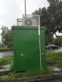
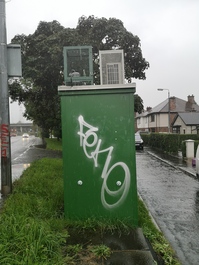
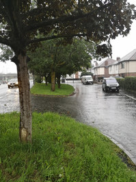
The monitoring station is within a self-contained air conditioned mobile unit along the road side of A55 - Stockman's Lane road, in the south western outskirts of Belfast's city centre, near the northern edge of Musgrave Park. The surrounding area is mainly open to the south. A small residential area surrounds the site from the north. Shane Retail Park lies at 55 meters to the Northeast, and the M1 motorway - 150 meters to the northwest. The monitoring station is located approximately 3.5 metres from the kerb.
UK-AIR ID: UKA00594
EU Site ID: GB1036A
Altitude (metres): 9
Environment Type: Urban Traffic
Site Location
Environment Type: Urban Traffic
Site Address: Not available
Government Region: Northern Ireland
Easting/Northing: 143191, 526975
Latitude/Longitude: 54.572586, -5.974944
The static map below shows where the monitoring site is located.
» View this location on Google Maps (new window)
» View this monitoring site on the interactive monitoring networks map
Partners
The Partners who operate networks at this monitoring sites are shown in the table below. Clicking on the Partner name will open their website in a new window.
| Operator | Networks |
|---|---|
| Bureau Veritas | Automatic Urban Monitoring Network |
Pollutants measured at this monitoring site
The pollutants measured at this monitoring site, grouped by network, are shown below.
Automatic Urban Monitoring Network
| Pollutant | Start Date | End Date | Inlet Height (m) | Hourly PM Measurement method |
|---|---|---|---|---|
| Nitric oxide | 07/06/2014 | - | 3.5 | |
| Nitrogen dioxide | 07/06/2014 | - | 3.5 | |
| Nitrogen oxides as nitrogen dioxide | 07/06/2014 | - | 3.5 | |
| PM10 particulate matter (Hourly measured) | 07/06/2014 | - | 3.5 | BAM |
| Modelled Wind Direction | 07/06/2014 | - | 4.0 | |
| Modelled Wind Speed | 07/06/2014 | - | 4.0 | |
| Modelled Temperature | 07/06/2014 | - | 2 |
Networks measured at this monitoring site
The listing below shows the networks that this monitoring site belongs to. You can search for sites within these networks by clicking on their name, or use the network information links to find out more about them.
| Network | Search | Further Details | Get Data |
|---|---|---|---|
| Automatic Urban and Rural Monitoring Network (AURN) | Automatic Urban and Rural Monitoring Network (AURN) | About network | Latest pollution summary Current Levels Pre-Formatted Data Files |