
Site Information for Grangemouth(UKA00420)
Grangemouth Information
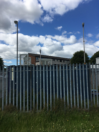
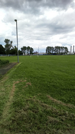
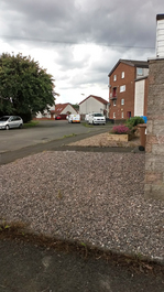
The monitoring station located within a self contained, air conditioned housing within a public park, next to a residential area. It has an open aspect to a BP petro-chemical complex 300m to the north. The nearest road is approximately 50 metres from the station, and is a residential access road.
UK-AIR ID: UKA00420
EU Site ID: GB0735A
Altitude (metres): 4
Environment Type: Urban Industrial
Site Location
Environment Type: Urban Industrial
Site Address: Grangemouth
Government Region: Central Scotland
Easting/Northing: 293830, 681021
Latitude/Longitude: 56.010319, -3.704399
The static map below shows where the monitoring site is located.
» View this location on Google Maps (new window)
» View this monitoring site on the interactive monitoring networks map
Partners
The Partners who operate networks at this monitoring sites are shown in the table below. Clicking on the Partner name will open their website in a new window.
| Operator | Networks |
|---|---|
| Bureau Veritas | Automatic Urban Monitoring Network |
| Ricardo Energy & Environment | Non-Automatic Hydrocarbon Network |
Pollutants measured at this monitoring site
The pollutants measured at this monitoring site, grouped by network, are shown below. Use the links below to quickly jump to a specific network.
Automatic Urban Monitoring Network
| Pollutant | Start Date | End Date | Inlet Height (m) | Hourly PM Measurement method |
|---|---|---|---|---|
| Nitric oxide | 01/01/2001 | - | 2.8 | |
| Nitrogen dioxide | 01/01/2001 | - | 2.8 | |
| Nitrogen oxides as nitrogen dioxide | 01/01/2001 | - | 2.8 | |
| Sulphur dioxide | 01/01/2001 | - | 2.8 | |
| Carbon monoxide | 17/01/2003 | 30/09/2007 | Not available | |
| PM10 particulate matter (Hourly measured) | 01/01/2001 | - | 2.8 | BAM |
| Non-volatile PM10 (Hourly measured) | 16/04/2009 | 06/06/2018 | Not available | FDMS |
| Volatile PM10 (Hourly measured) | 16/04/2009 | 06/06/2018 | Not available | FDMS |
| PM2.5 particulate matter (Hourly measured) | 03/12/2008 | - | 2.8 | BAM |
| Non-volatile PM2.5 (Hourly measured) | 03/12/2008 | 05/06/2018 | Not available | FDMS |
| Volatile PM2.5 (Hourly measured) | 03/12/2008 | 05/06/2018 | Not available | FDMS |
| Modelled Wind Direction | 01/08/2010 | - | 10 | |
| Modelled Wind Speed | 01/08/2010 | - | 10 | |
| Modelled Temperature | 01/08/2010 | - | 2 |
multi-element
| Pollutant | Start Date | End Date | Inlet Height (m) |
|---|---|---|---|
| Antimony | 04/11/1975 | 28/02/1978 | Not available |
| Arsenic | 04/11/1975 | 28/02/1978 | Not available |
| Beryllium | 04/11/1975 | 28/02/1978 | Not available |
| Cadmium | 04/11/1975 | 28/02/1978 | Not available |
| Chromium | 04/11/1975 | 28/02/1978 | Not available |
| Cobalt | 04/11/1975 | 28/02/1978 | Not available |
| Copper | 04/11/1975 | 28/02/1978 | Not available |
| Iron | 04/11/1975 | 28/02/1978 | Not available |
| Lead | 04/11/1975 | 28/02/1978 | Not available |
| Manganese | 04/11/1975 | 28/02/1978 | Not available |
| Molybdenum | 04/11/1975 | 28/02/1978 | Not available |
| Nickel | 04/11/1975 | 28/02/1978 | Not available |
| Titanium | 04/11/1975 | 28/02/1978 | Not available |
| Vanadium | 04/11/1975 | 28/02/1978 | Not available |
| Zinc | 04/11/1975 | 28/02/1978 | Not available |
Non-Automatic Hydrocarbon Network
| Pollutant | Start Date | End Date | Inlet Height (m) |
|---|---|---|---|
| 1,3-butadiene | 26/05/2003 | 06/09/2007 | Not available |
| benzene | 06/03/2002 | - | 4.0 |
Networks measured at this monitoring site
The listing below shows the networks that this monitoring site belongs to. You can search for sites within these networks by clicking on their name, or use the network information links to find out more about them.
| Network | Search | Further Details | Get Data |
|---|---|---|---|
| Automatic Urban and Rural Monitoring Network (AURN) | Automatic Urban and Rural Monitoring Network (AURN) | About network | Latest pollution summary Current Levels Pre-Formatted Data Files |
| Non-Automatic Hydrocarbon Network | Non-Automatic Hydrocarbon Network | About network | Network Information page |
| Urban Sulphate | Not available | About network | Data Selector |