
Site Information for Wirral Tranmere(UKA00406)
Wirral Tranmere Information
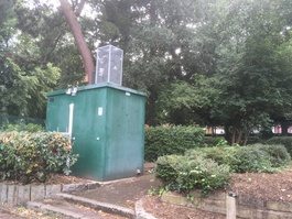
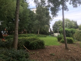
The monitoring station is housed within a self-contained, air-conditioned unit located within the fenced Community Garden which forms part of Victoria Park in Tranmere. The manifold is approximately 50 metres from the nearest minor road, Bebington Road. The Park is approximately 11.6 hectares in size and is bound by residential areas. There is a Gas facility 1.2 kilometres to the west on the banks of the River Mersey.
UK-AIR ID: UKA00406
EU Site ID: GB0730A
Altitude (metres): 38
Environment Type: Urban Background
PM2.5 Targets This site is used in the assessment of both the Annual Mean Concentration Target (AMCT) and Population Exposure Reduction Target (PERT) under the Environmental Target (Fine Particulate Matter) (England) Regulations 2023, subject to meeting the inclusion criteria on an annual basis. To find out more about how measurements are used to calculate progress towards the targets and which sites have met the inclusion criteria in different years, please see the PM2.5 target calculation page.
Site Location
Environment Type: Urban Background
Site Address: Liverpool
Government Region: North West & Merseyside
Easting/Northing: 332054, 386711
Latitude/Longitude: 53.372870, -3.022722


The static map below shows where the monitoring site is located.
» View this location on Google Maps (new window)
» View this monitoring site on the interactive monitoring networks map
Partners
The Partners who operate networks at this monitoring sites are shown in the table below. Clicking on the Partner name will open their website in a new window.
| Operator | Networks |
|---|---|
| Bureau Veritas | Automatic Urban Monitoring Network |
Pollutants measured at this monitoring site
The pollutants measured at this monitoring site, grouped by network, are shown below.
Automatic Urban Monitoring Network
| Pollutant | Start Date | End Date | Inlet Height (m) | Hourly PM Measurement method |
|---|---|---|---|---|
| Ozone | 14/05/2000 | - | 2.5 | |
| Nitric oxide | 14/05/2000 | - | 2.5 | |
| Nitrogen dioxide | 14/05/2000 | - | 2.5 | |
| Nitrogen oxides as nitrogen dioxide | 14/05/2000 | - | 2.5 | |
| Sulphur dioxide | 14/05/2000 | 30/09/2007 | Not available | |
| Carbon monoxide | 14/05/2000 | 30/09/2007 | Not available | |
| PM10 particulate matter (Hourly measured) | 14/05/2000 | - | 2.5 | FIDAS |
| Non-volatile PM10 (Hourly measured) | 16/07/2007 | 28/01/2009 | Not available | FDMS |
| Volatile PM10 (Hourly measured) | 16/07/2007 | 28/01/2009 | Not available | FDMS |
| PM2.5 particulate matter (Hourly measured) | 28/01/2009 | - | 2.5 | FIDAS |
| Non-volatile PM2.5 (Hourly measured) | 28/01/2009 | 19/08/2019 | Not available | FDMS |
| Volatile PM2.5 (Hourly measured) | 28/01/2009 | 19/08/2019 | Not available | FDMS |
| Modelled Wind Direction | 01/08/2010 | - | 10 | |
| Modelled Wind Speed | 01/08/2010 | - | 10 | |
| Modelled Temperature | 01/08/2010 | - | 2 |
Networks measured at this monitoring site
The listing below shows the networks that this monitoring site belongs to. You can search for sites within these networks by clicking on their name, or use the network information links to find out more about them.
| Network | Search | Further Details | Get Data |
|---|---|---|---|
| Automatic Urban and Rural Monitoring Network (AURN) | Automatic Urban and Rural Monitoring Network (AURN) | About network | Latest pollution summary Current Levels Pre-Formatted Data Files |