
Site Information for Norwich Forum Roadside(UKA00485)
Please Note: This monitoring site is closed.
Norwich Forum Roadside Information
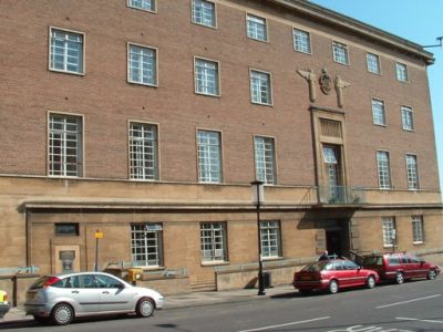
Height above sea level 25m Description The monitoring station is within the City Hall, approximately 5 metres from a 2-lane urban street. Traffic flow is moderate and is subject to occasional queuing. The manifold inlet is approximately 4 metres high and is mounted close to the building facade. The surrounding area comprises retail outlet and business premises.
UK-AIR ID: UKA00485
EU Site ID: GB0862A
Altitude (metres): 25
Environment Type: Urban Traffic
Site Location
Environment Type: Urban Traffic
Site Address: Norwich
Government Region: Eastern
Easting/Northing: 622873, 308466
Latitude/Longitude: 52.628170, 1.291714

The static map below shows where the monitoring site is located.
» View this location on Google Maps (new window)
Partners
Sorry, no information is currently available
Pollutants measured at this monitoring site
The pollutants measured at this monitoring site, grouped by network, are shown below.
Automatic Urban Monitoring Network
| Pollutant | Start Date | End Date | Inlet Height (m) | Hourly PM Measurement method |
|---|---|---|---|---|
| Nitric oxide | 08/04/2005 | 30/09/2007 | Not available | |
| Nitrogen dioxide | 08/04/2005 | 30/09/2007 | Not available | |
| Nitrogen oxides as nitrogen dioxide | 08/04/2005 | 30/09/2007 | Not available |
Networks measured at this monitoring site
The listing below shows the networks that this monitoring site belongs to. You can search for sites within these networks by clicking on their name, or use the network information links to find out more about them.
| Network | Search | Further Details | Get Data |
|---|---|---|---|
| Automatic Urban and Rural Monitoring Network (AURN) | Automatic Urban and Rural Monitoring Network (AURN) | About network | Latest pollution summary Current Levels Pre-Formatted Data Files |