
Site Information for Manchester Piccadilly(UKA00248)
Site Observations
Redevelopment and construction work is in progress in the vicinity of the Manchester Piccadilly monitoring station. This may lead to localised higher concentrations of some pollutants.
Manchester Piccadilly Information
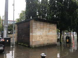
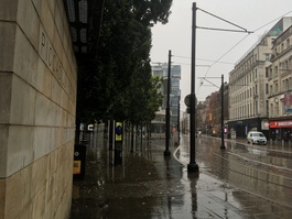
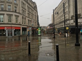
The monitoring station is within a self contained air conditioned housing in the west-end of central Manchester in a pedestrianised zone approx 3 metres from (electric) tramline. The nearest major road, the A5103 Portland Street is approximately 200 metres from the station. The surrounding area is generally open with commercial property. The site can be exposed to short term pollution events related to nearby food stalls or if events occur in the square.
UK-AIR ID: UKA00248
EU Site ID: GB0613A
Altitude (metres): 57
Environment Type: Urban Background
PM2.5 Targets This site is used in the assessment of both the Annual Mean Concentration Target (AMCT) and Population Exposure Reduction Target (PERT) under the Environmental Target (Fine Particulate Matter) (England) Regulations 2023, subject to meeting the inclusion criteria on an annual basis. To find out more about how measurements are used to calculate progress towards the targets and which sites have met the inclusion criteria in different years, please see the PM2.5 target calculation page.
Site Location
Environment Type: Urban Background
Site Address: Manchester
Government Region: North West & Merseyside
Easting/Northing: 384311, 398337
Latitude/Longitude: 53.481520, -2.237881
The static map below shows where the monitoring site is located.
» View this location on Google Maps (new window)
» View this monitoring site on the interactive monitoring networks map
Partners
The Partners who operate networks at this monitoring sites are shown in the table below. Clicking on the Partner name will open their website in a new window.
| Operator | Networks |
|---|---|
| Bureau Veritas | Automatic Urban Monitoring Network |
| Ricardo Energy & Environment | Non-Automatic Hydrocarbon Network |
Pollutants measured at this monitoring site
The pollutants measured at this monitoring site, grouped by network, are shown below. Use the links below to quickly jump to a specific network.
- Automatic Urban Monitoring Network
- Non-Automatic Hydrocarbon Network
- Partisol Research
- UK Black Carbon Network
Automatic Urban Monitoring Network
| Pollutant | Start Date | End Date | Inlet Height (m) | Hourly PM Measurement method |
|---|---|---|---|---|
| Ozone | 18/12/1995 | - | 3.7 | |
| Nitric oxide | 18/12/1995 | - | 3.7 | |
| Nitrogen dioxide | 18/12/1995 | - | 3.7 | |
| Nitrogen oxides as nitrogen dioxide | 18/12/1995 | - | 3.7 | |
| Sulphur dioxide | 18/12/1995 | - | 3.7 | |
| Carbon monoxide | 18/12/1995 | 30/09/2007 | Not available | |
| PM10 particulate matter (Hourly measured) | 18/12/1995 | - | 3.7 | FIDAS |
| Non-volatile PM10 (Hourly measured) | 15/03/2007 | 15/01/2009 | Not available | FDMS |
| Volatile PM10 (Hourly measured) | 15/03/2007 | 15/01/2009 | Not available | FDMS |
| PM2.5 particulate matter (Hourly measured) | 15/01/2009 | - | 3.7 | FIDAS |
| Non-volatile PM2.5 (Hourly measured) | 15/01/2009 | 31/12/2019 | Not available | FDMS |
| Volatile PM2.5 (Hourly measured) | 15/01/2009 | 31/12/2019 | Not available | FDMS |
| Modelled Wind Direction | 01/08/2010 | - | 10 | |
| Modelled Wind Speed | 01/08/2010 | - | 10 | |
| Modelled Temperature | 01/08/2010 | - | 2 |
Non-Automatic Hydrocarbon Network
| Pollutant | Start Date | End Date | Inlet Height (m) |
|---|---|---|---|
| benzene | 20/03/2002 | - | 4.0 |
Partisol Research
| Pollutant | Start Date | End Date | Inlet Height (m) |
|---|---|---|---|
| PM10 particulate matter (Daily measured) | 21/03/2002 | 04/10/2007 | Not available |
| PM2.5 particulate matter (Daily measured) | 28/02/2002 | 04/10/2007 | Not available |
| Daily measured PM10 (uncorrected) | 21/03/2002 | 04/10/2007 | Not available |
| Daily measured PM2.5 (uncorrected) | 28/02/2002 | 04/10/2007 | Not available |
UK Black Carbon Network
| Pollutant | Start Date | End Date | Inlet Height (m) |
|---|---|---|---|
| Black smoke | 30/09/2006 | 27/10/2008 | Not available |
| Black Carbon (880nm) | 31/10/2008 | 22/03/2012 | 4.0 |
| UV Particulate Matter (UV-BC) | 31/10/2008 | 22/03/2012 | 4.0 |
Networks measured at this monitoring site
The listing below shows the networks that this monitoring site belongs to. You can search for sites within these networks by clicking on their name, or use the network information links to find out more about them.
| Network | Search | Further Details | Get Data |
|---|---|---|---|
| Automatic Urban and Rural Monitoring Network (AURN) | Automatic Urban and Rural Monitoring Network (AURN) | About network | Latest pollution summary Current Levels Pre-Formatted Data Files |
| Automatic Urban and Rural Monitoring Network (AURN) | Automatic Urban and Rural Monitoring Network (AURN) | About network | Data Selector |
| Black Carbon | Black Carbon | About network | Data Selector |
| Non-Automatic Hydrocarbon Network | Non-Automatic Hydrocarbon Network | About network | Network Information page |