
Site Information for Glasgow High Street(UKA00602)
Glasgow High Street Information
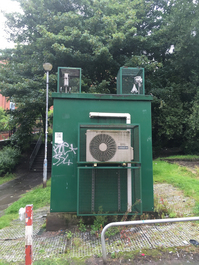
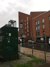
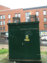
The monitoring station is within a self-contained air conditioned mobile unit along the roadside of High Street, in Glasgow's city centre, opposite Burrell's Lane. The surrounding area comprises residential houses and business and retail outlets, in an urban environment. High street railway station lies approximately 200 meters to the southwest. The monitoring station is located approximately 5.5 metres from the kerb.
UK-AIR ID: UKA00602
EU Site ID: GB1044A
Altitude (metres): 35
Environment Type: Urban Traffic
Site Location
Environment Type: Urban Traffic
Site Address: Glasgow
Government Region: Central Scotland
Easting/Northing: 260014, 665349
Latitude/Longitude: 55.860936, -4.238214


The static map below shows where the monitoring site is located.
» View this location on Google Maps (new window)
» View this monitoring site on the interactive monitoring networks map
Partners
The Partners who operate networks at this monitoring sites are shown in the table below. Clicking on the Partner name will open their website in a new window.
| Operator | Networks |
|---|---|
| Bureau Veritas | Automatic Urban Monitoring Network |
| National Physical Laboratory | UK Black Carbon Network |
Pollutants measured at this monitoring site
The pollutants measured at this monitoring site, grouped by network, are shown below. Use the links below to quickly jump to a specific network.
Automatic Urban Monitoring Network
| Pollutant | Start Date | End Date | Inlet Height (m) | Hourly PM Measurement method |
|---|---|---|---|---|
| Nitric oxide | 27/01/2015 | - | 3.5 | |
| Nitrogen dioxide | 27/01/2015 | - | 3.5 | |
| Nitrogen oxides as nitrogen dioxide | 27/01/2015 | - | 3.5 | |
| PM10 particulate matter (Hourly measured) | 27/01/2015 | - | 3.5 | FIDAS |
| Non-volatile PM10 (Hourly measured) | 27/01/2015 | 02/11/2018 | 3.5 | FDMS |
| Volatile PM10 (Hourly measured) | 27/01/2015 | 02/11/2018 | 3.5 | FDMS |
| PM2.5 particulate matter (Hourly measured) | 27/01/2015 | - | 3.5 | FIDAS |
| Non-volatile PM2.5 (Hourly measured) | 27/01/2015 | 02/11/2018 | 3.5 | FDMS |
| Volatile PM2.5 (Hourly measured) | 27/01/2015 | 02/11/2018 | 3.5 | FDMS |
| Modelled Wind Direction | 27/01/2015 | - | 10 | |
| Modelled Wind Speed | 27/01/2015 | - | 10 | |
| Modelled Temperature | 27/01/2015 | - | 2 |
UK Black Carbon Network
| Pollutant | Start Date | End Date | Inlet Height (m) |
|---|---|---|---|
| Black Carbon (880nm) | 04/03/2015 | - | 3.0 |
| UV Particulate Matter (UV-BC) | 04/03/2015 | - | 3.0 |
| Infra Red Particulate matter (950nm) | 05/11/2019 | - | 3.0 |
| Red Particulate matter (660nm) | 05/11/2019 | - | 3.0 |
| Yellow Particulate matter (590nm) | 05/11/2019 | - | 3.0 |
| Green Particulate matter (520nm) | 05/11/2019 | - | 3.0 |
| Blue Particulate matter (470nm) | 05/11/2019 | - | 3.0 |
| UV Particulate Matter (370nm) | 05/11/2019 | - | 3.0 |
UK Urban NO2 Network
| Pollutant | Start Date | End Date | Inlet Height (m) |
|---|---|---|---|
| Nitrogen dioxide (corrected) | 10/12/2020 | - | 2.5 |
Networks measured at this monitoring site
The listing below shows the networks that this monitoring site belongs to. You can search for sites within these networks by clicking on their name, or use the network information links to find out more about them.
| Network | Search | Further Details | Get Data |
|---|---|---|---|
| Automatic Urban and Rural Monitoring Network (AURN) | Automatic Urban and Rural Monitoring Network (AURN) | About network | Latest pollution summary Current Levels Pre-Formatted Data Files |
| Black Carbon | Black Carbon | About network | Data Selector |
| UK Urban NO2 Network | UK Urban NO2 Network | About network | Data Selector Network Information page |