
Site Information for Armagh Roadside(UKA00541)
Armagh Roadside Information
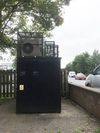
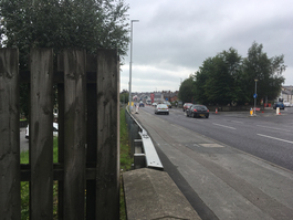
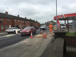
The monitoring station is within a self-contained, air-conditioned housing at the junction of Railway Street and the A29 Lonsdale Road. The immediate area is residential with commercial and light industrial areas nearby. The monitoring station is located approximately 4.5 metres from the kerb.
UK-AIR ID: UKA00541
EU Site ID: GB0996A
Altitude (metres): 41
Environment Type: Urban Traffic
Site Location
Environment Type: Urban Traffic
Site Address: Armagh
Government Region: Northern Ireland
Easting/Northing: 97684, 505347
Latitude/Longitude: 54.353728, -6.654558
The static map below shows where the monitoring site is located.
» View this location on Google Maps (new window)
» View this monitoring site on the interactive monitoring networks map
Partners
The Partners who operate networks at this monitoring sites are shown in the table below. Clicking on the Partner name will open their website in a new window.
| Operator | Networks |
|---|---|
| Bureau Veritas | Automatic Urban Monitoring Network |
Pollutants measured at this monitoring site
The pollutants measured at this monitoring site, grouped by network, are shown below. Use the links below to quickly jump to a specific network.
Automatic Urban Monitoring Network
| Pollutant | Start Date | End Date | Inlet Height (m) | Hourly PM Measurement method |
|---|---|---|---|---|
| Nitric oxide | 01/01/2009 | - | 3.3 | |
| Nitrogen dioxide | 01/01/2009 | - | 3.3 | |
| Nitrogen oxides as nitrogen dioxide | 01/01/2009 | - | 3.3 | |
| PM10 particulate matter (Hourly measured) | 01/01/2009 | - | 3.3 | BAM |
| Non-volatile PM10 (Hourly measured) | 03/09/2010 | 06/02/2020 | 2 | FDMS |
| Volatile PM10 (Hourly measured) | 03/09/2010 | 06/02/2020 | 2 | FDMS |
| Modelled Wind Direction | 01/08/2010 | - | 10 | |
| Modelled Wind Speed | 01/08/2010 | - | 1.5 | |
| Modelled Temperature | 01/08/2010 | - | 1.5 |
PAH Digitel (solid phase)
| Pollutant | Start Date | End Date | Inlet Height (m) |
|---|---|---|---|
| Benzo(a)pyrene | 20/10/2022 | - | 2.0 |
| Benzo(a)anthracene | 20/10/2022 | - | 2.0 |
| Benzo(b)fluoranthene | 20/10/2022 | - | 2.0 |
| Benzo(j)fluoranthene | 20/10/2022 | - | 2.0 |
| Benzo(k)fluoranthene | 20/10/2022 | - | 2.0 |
| Indeno(1,2,3-cd)pyrene | 20/10/2022 | - | 2.0 |
| Dibenzo(ac)anthracene | 20/10/2022 | - | 2.0 |
| Dibenzo(ah)anthracene | 20/10/2022 | - | 2.0 |
| 5-Methyl Chrysene | 20/10/2022 | - | 2.0 |
| Anthanthrene | 20/10/2022 | - | 2.0 |
| Anthracene | 20/10/2022 | - | 2.0 |
| Benzo(b)naphtho(2,1-d)thiophene | 20/10/2022 | - | 2.0 |
| Benzo(c)phenanthrene | 20/10/2022 | - | 2.0 |
| Benzo(e)pyrene | 20/10/2022 | - | 2.0 |
| Benzo(ghi)perylene | 20/10/2022 | - | 2.0 |
| Chrysene | 20/10/2022 | - | 2.0 |
| Coronene | 20/10/2022 | - | 2.0 |
| Cyclopenta(c,d)pyrene | 20/10/2022 | - | 2.0 |
| Dibenzo(al)pyrene | 20/10/2022 | - | 2.0 |
| Dibenzo(ae)pyrene | 20/10/2022 | - | 2.0 |
| Dibenzo(ai)pyrene | 20/10/2022 | - | 2.0 |
| Dibenzo(ah)pyrene | 20/10/2022 | - | 2.0 |
| Fluoranthene | 20/10/2022 | - | 2.0 |
| Perylene | 20/10/2022 | - | 2.0 |
| Phenanthrene | 20/10/2022 | - | 2.0 |
| Pyrene | 20/10/2022 | - | 2.0 |
| Retene | 20/10/2022 | - | 2.0 |
Networks measured at this monitoring site
The listing below shows the networks that this monitoring site belongs to. You can search for sites within these networks by clicking on their name, or use the network information links to find out more about them.
| Network | Search | Further Details | Get Data |
|---|---|---|---|
| Automatic Urban and Rural Monitoring Network (AURN) | Automatic Urban and Rural Monitoring Network (AURN) | About network | Latest pollution summary Current Levels Pre-Formatted Data Files |
| PAH Digitel (solid phase) | PAH Digitel (solid phase) | About network | PAH data download page |