
Site Information for Bury Roadside(UKA00322)
Please Note: This monitoring site is closed.
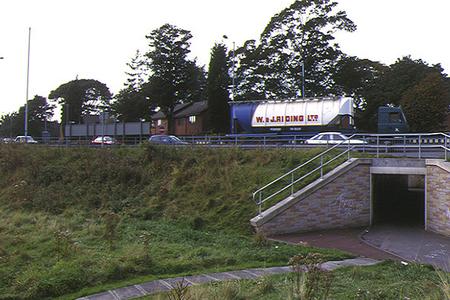
Bury Roadside Information
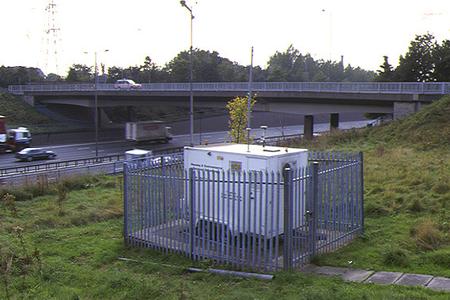
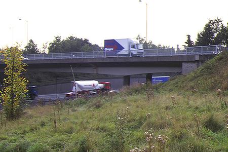
The monitoring station is located within a self-contained, air conditioned housing located on the embankment of Junction 17, 16 metres away from the M60 motorway which has an annual average traffic flow of 162,000 vehicles. Within 21 metres distance of the site is a 3-lane roundabout The motorway and roundabout are subject to frequent congestion during peak traffic flow periods. The manifold inlet is approximately 3 metres above ground level. The surrounding area is generally open.
UK-AIR ID: UKA00322
EU Site ID: GB0652A
Altitude (metres): 50
Environment Type: Urban Traffic
Site Location
Environment Type: Urban Traffic
Site Address: Bury
Government Region: North West & Merseyside
Easting/Northing: 380904, 404757
Latitude/Longitude: 53.539110, -2.289611
The static map below shows where the monitoring site is located.
» View this location on Google Maps (new window)
Partners
The Partners who operate networks at this monitoring sites are shown in the table below. Clicking on the Partner name will open their website in a new window.
| Operator | Networks |
|---|---|
| Ricardo Energy & Environment | Non-Automatic Hydrocarbon Network |
Pollutants measured at this monitoring site
The pollutants measured at this monitoring site, grouped by network, are shown below. Use the links below to quickly jump to a specific network.
Automatic Urban Monitoring Network
| Pollutant | Start Date | End Date | Inlet Height (m) | Hourly PM Measurement method |
|---|---|---|---|---|
| Ozone | 20/01/1997 | 30/09/2007 | Not available | |
| Nitric oxide | 20/01/1997 | 06/09/2012 | Not available | |
| Nitrogen dioxide | 20/01/1997 | 06/09/2012 | Not available | |
| Nitrogen oxides as nitrogen dioxide | 20/01/1997 | 06/09/2012 | Not available | |
| Sulphur dioxide | 20/01/1997 | 31/12/2007 | Not available | |
| Carbon monoxide | 20/01/1997 | 06/09/2012 | Not available | |
| PM10 particulate matter (Hourly measured) | 20/01/1997 | 06/09/2012 | Not available | FDMS |
| Non-volatile PM10 (Hourly measured) | 07/05/2009 | 06/09/2012 | Not available | FDMS |
| Volatile PM10 (Hourly measured) | 07/05/2009 | 06/09/2012 | Not available | FDMS |
| PM2.5 particulate matter (Hourly measured) | 07/05/2009 | 06/09/2012 | Not available | FDMS |
| Non-volatile PM2.5 (Hourly measured) | 07/05/2009 | 06/09/2012 | Not available | FDMS |
| Volatile PM2.5 (Hourly measured) | 07/05/2009 | 06/09/2012 | Not available | FDMS |
| Modelled Wind Direction | 01/08/2010 | 06/09/2012 | 10 | |
| Modelled Wind Speed | 01/08/2010 | 06/09/2012 | 10 | |
| Modelled Temperature | 01/08/2010 | 06/09/2012 | 2 |
Non-Automatic Hydrocarbon Network
| Pollutant | Start Date | End Date | Inlet Height (m) |
|---|---|---|---|
| benzene | 03/01/2008 | 10/09/2013 | 101.0 |
Networks measured at this monitoring site
The listing below shows the networks that this monitoring site belongs to. You can search for sites within these networks by clicking on their name, or use the network information links to find out more about them.
| Network | Search | Further Details | Get Data |
|---|---|---|---|
| Automatic Urban and Rural Monitoring Network (AURN) | Automatic Urban and Rural Monitoring Network (AURN) | About network | Latest pollution summary Current Levels Pre-Formatted Data Files |
| Non-Automatic Hydrocarbon Network | Non-Automatic Hydrocarbon Network | About network | Network Information page |