
Site Information for Barnsley Gawber(UKA00353)
Barnsley Gawber Information
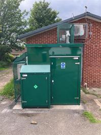
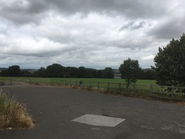
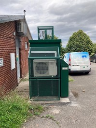
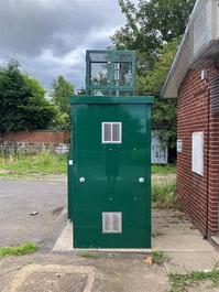
The monitoring station is within a free-standing enclosure located on the edge of a sports field surrounded on two sides by residential properties. The site is situated approximately 290 metres from the nearest main road, Wilthorpe Road (A635). The surrounding area comprises of open space and nearby residential premises.
UK-AIR ID: UKA00353
EU Site ID: GB0681A
Altitude (metres): 100
Environment Type: Urban Background
PM2.5 Targets This site is used in the assessment of both the Annual Mean Concentration Target (AMCT) and Population Exposure Reduction Target (PERT) under the Environmental Target (Fine Particulate Matter) (England) Regulations 2023, subject to meeting the inclusion criteria on an annual basis. To find out more about how measurements are used to calculate progress towards the targets and which sites have met the inclusion criteria in different years, please see the PM2.5 target calculation page.
Site Location
Environment Type: Urban Background
Site Address: Barnsley
Government Region: Yorkshire & Humberside
Easting/Northing: 432524, 407478
Latitude/Longitude: 53.562920, -1.510436
The static map below shows where the monitoring site is located.
» View this location on Google Maps (new window)
» View this monitoring site on the interactive monitoring networks map
Partners
The Partners who operate networks at this monitoring sites are shown in the table below. Clicking on the Partner name will open their website in a new window.
| Operator | Networks |
|---|---|
| Bureau Veritas | Automatic Urban Monitoring Network |
| Ricardo Energy & Environment | Non-Automatic Hydrocarbon Network |
| National Physical Laboratory | UK Black Carbon Network |
Pollutants measured at this monitoring site
The pollutants measured at this monitoring site, grouped by network, are shown below. Use the links below to quickly jump to a specific network.
Automatic Urban Monitoring Network
| Pollutant | Start Date | End Date | Inlet Height (m) | Hourly PM Measurement method |
|---|---|---|---|---|
| Ozone | 07/07/1997 | - | 2.0 | |
| Nitric oxide | 07/07/1997 | - | 2.0 | |
| Nitrogen dioxide | 07/07/1997 | - | 2.0 | |
| Nitrogen oxides as nitrogen dioxide | 07/07/1997 | - | 2.0 | |
| Sulphur dioxide | 07/07/1997 | - | 2.0 | |
| Carbon monoxide | 08/07/2002 | 30/09/2007 | Not available | |
| PM10 particulate matter (Hourly measured) | 06/04/2023 | - | 2.0 | FIDAS |
| PM2.5 particulate matter (Hourly measured) | 06/04/2023 | - | 2.0 | FIDAS |
| Modelled Wind Direction | 01/08/2010 | - | 10 | |
| Modelled Wind Speed | 01/08/2010 | - | 10 | |
| Modelled Temperature | 01/08/2010 | - | 2 |
Non-Automatic Hydrocarbon Network
| Pollutant | Start Date | End Date | Inlet Height (m) |
|---|---|---|---|
| benzene | 02/08/2002 | - | 5.0 |
UK Black Carbon Network
| Pollutant | Start Date | End Date | Inlet Height (m) |
|---|---|---|---|
| Black Carbon (880nm) | 17/04/2024 | - | 2.0 |
| UV Particulate Matter (UV-BC) | 17/04/2024 | - | 2.0 |
| Infra Red Particulate matter (950nm) | 17/04/2024 | - | 2.0 |
| Red Particulate matter (660nm) | 17/04/2024 | - | 2.0 |
| Yellow Particulate matter (590nm) | 17/04/2024 | - | 2.0 |
| Green Particulate matter (520nm) | 17/04/2024 | - | 2.0 |
| Blue Particulate matter (470nm) | 17/04/2024 | - | 2.0 |
| UV Particulate Matter (370nm) | 17/04/2024 | - | 2.0 |
Networks measured at this monitoring site
The listing below shows the networks that this monitoring site belongs to. You can search for sites within these networks by clicking on their name, or use the network information links to find out more about them.
| Network | Search | Further Details | Get Data |
|---|---|---|---|
| Automatic Urban and Rural Monitoring Network (AURN) | Automatic Urban and Rural Monitoring Network (AURN) | About network | Latest pollution summary Current Levels Pre-Formatted Data Files |
| Black Carbon | Black Carbon | About network | Data Selector |
| Non-Automatic Hydrocarbon Network | Non-Automatic Hydrocarbon Network | About network | Network Information page |