
Site Information for Manchester University(UKA00577)
Manchester University Information
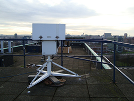
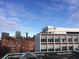
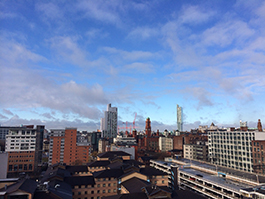
The Manchester Solar Radiation Monitoring site is located on the top of the 35m tall Pariser Building, University of Manchester. It is located at the southern edge of the core of Manchester city centre such that the site and instruments have a mostly clear view of the horizon, particularly to the south. Manchester is a generally low level site (typical elevations < 100m), the closest hills being the Peak District 20km to the east
UK-AIR ID: UKA00577
EU Site ID: GB0418A
Altitude (metres): 76
Environment Type: Urban Background
Site Location
Environment Type: Urban Background
Site Address: Not available
Government Region: North West & Merseyside
Easting/Northing: 384581, 397546
Latitude/Longitude: 53.474417, -2.233773
The static map below shows where the monitoring site is located.
» View this location on Google Maps (new window)
» View this monitoring site on the interactive monitoring networks map
Partners
The Partners who operate networks at this monitoring sites are shown in the table below. Clicking on the Partner name will open their website in a new window.
| Operator | Networks |
|---|---|
| University of Manchester | Ozone-UV |
Pollutants measured at this monitoring site
The pollutants measured at this monitoring site, grouped by network, are shown below.
Ozone-UV
| Pollutant | Start Date | End Date | Inlet Height (m) |
|---|---|---|---|
| Stratospheric Ozone | 27/05/1997 | - | 1.5 |
| Total Ultraviolet radiation | 27/05/1997 | - | 1.5 |
Networks measured at this monitoring site
The listing below shows the networks that this monitoring site belongs to. You can search for sites within these networks by clicking on their name, or use the network information links to find out more about them.
| Network | Search | Further Details | Get Data |
|---|---|---|---|
| Ozone / UV | Not available | About network | Stratospheric Ozone Data UV Radiation Data |