
View with Google Earth
![]() Using Google Earth, you can view the latest data and information for all automatic air quality monitoring sites in the UK national network. All the data is automatically refreshed every hour.
Using Google Earth, you can view the latest data and information for all automatic air quality monitoring sites in the UK national network. All the data is automatically refreshed every hour.
It's easy to get started, just follow the steps below:
STEP ONE: Download Google Earth
Google Earth is free to download, and is available from Google for PC and Mac or Linux. Just visit https://www.google.com/earth/about/versions/#download-pro and click on the "Agree and Download" button once you have reviewed the terms and conditions.
Once downloaded, open the installer file and let Google Earth install on your computer.
![]()
STEP TWO: Download the KMZ file
Once you have Google Earth installed on your computer, you can download the specially developed KMZ file from these air quality pages. A KMZ file is specifically designed for showing information using Google Earth.
Click on the "Download KMZ File" link below to open the KMZ file:
![]() Download KMZ File (KMZ 1KB)
Download KMZ File (KMZ 1KB)
Please Note: Google Earth version 4 or above is required for this KMZ file.
![]()
STEP THREE: Open the KMZ file using Google Earth
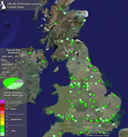
Overview
When you open the KMZ file, the displayed globe will automatically zoom in to the UK. After a few seconds, the map will populate with different coloured spots showing both the position of the national monitoring stations, and their current air pollution band level. You can zoom in to view the map in more detail.
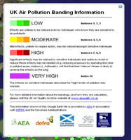
Bandings
A legend is shown giving you a quick overview of the air pollution bandings in the UK and the indexes associated with them. Just click on the link at the side "Banding Information" for more information about the bands.
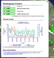
View Site Data
If you rollover any monitoring site spot, the site name will appear to help quickly locate which location you are viewing. Clicking on the spot will bring up a display showing more detailed air pollution information, including the latest levels for pollutants measured at the site, a weekly graph of pollutant levels, and links to find out more information.
Please note: All images shown in the screenshots are copyright Google © and Google Earth™ imagery shown belongs to the respective owner.