Site Information for Chepstow A48(UKA00515)
Chepstow A48 Information
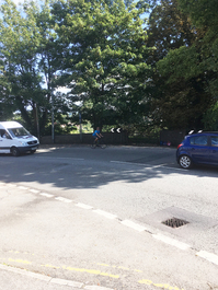
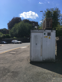
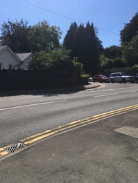
The monitoring station is located within a self contained air conditioned housing on the north side of the A48 Newport Road at the junction with Hardwick Hill Lane. The surrounding area is open with residential dwellings. The monitoring station is located approximately 6 metres from the kerb.
UK-AIR ID: UKA00515
EU Site ID: GB0921A
Altitude (metres): 67
Environment Type: Urban Traffic
Site Location
Environment Type: Urban Traffic
Site Address: Hardwick Hill Chepstow Chepstow
Government Region: South Wales
Easting/Northing: 353126, 193473
Latitude/Longitude: 51.638094, -2.678731

The static map below shows where the monitoring site is located.
» View this location on Google Maps (new window)
» View this monitoring site on the interactive monitoring networks map
Partners
The Partners who operate networks at this monitoring sites are shown in the table below. Clicking on the Partner name will open their website in a new window.
| Operator | Networks |
|---|---|
| Bureau Veritas | Automatic Urban Monitoring Network |
Pollutants measured at this monitoring site
The pollutants measured at this monitoring site, grouped by network, are shown below. Use the links below to quickly jump to a specific network.
Automatic Urban Monitoring Network
| Pollutant | Start Date | End Date | Inlet Height (m) | Hourly PM Measurement method |
|---|---|---|---|---|
| Nitric oxide | 01/01/2008 | - | 4.0 | |
| Nitrogen dioxide | 01/01/2008 | - | 4.0 | |
| Nitrogen oxides as nitrogen dioxide | 01/01/2008 | - | 4.0 | |
| PM10 particulate matter (Hourly measured) | 01/01/2008 | - | 4.0 | BAM1020heated |
| Non-volatile PM10 (Hourly measured) | 08/02/2010 | 09/08/2018 | 0.0 | |
| Volatile PM10 (Hourly measured) | 08/02/2010 | 09/08/2018 | 0.0 | |
| PM2.5 particulate matter (Hourly measured) | 09/02/2010 | - | 4.0 | BAM1020heated |
| Non-volatile PM2.5 (Hourly measured) | 09/02/2010 | 09/08/2018 | 0.0 | |
| Volatile PM2.5 (Hourly measured) | 09/02/2010 | 09/08/2018 | 0.0 | |
| Modelled Wind Direction | 01/08/2010 | - | Not available | |
| Modelled Wind Speed | 01/08/2010 | - | Not available | |
| Modelled Temperature | 01/08/2010 | - | Not available | |
| PM10 Ambient Temperature | 08/02/2010 | 09/08/2018 | Not available | |
| PM10 Ambient pressure measured | 08/02/2010 | 09/08/2018 | Not available | |
| PM2.5 Ambient Temperature | 09/02/2010 | 09/08/2018 | Not available | |
| PM2.5 Ambient Preasure | 09/02/2010 | 09/08/2018 | Not available |
UK Urban NO2 Network
| Pollutant | Start Date | End Date | Inlet Height (m) |
|---|---|---|---|
| Nitrogen dioxide (corrected) | 01/01/2020 | 31/01/2020 | Not available |
Networks measured at this monitoring site
The listing below shows the networks that this monitoring site belongs to. You can search for sites within these networks by clicking on their name, or use the network information links to find out more about them.
| Network | Search | Further Details | Get Data |
|---|---|---|---|
| Automatic Urban and Rural Monitoring Network (AURN) | Automatic Urban and Rural Monitoring Network (AURN) | About network | Latest pollution summary Current Levels Pre-Formatted Data Files |
| UK Urban NO2 Network | UK Urban NO2 Network | About network | Data Selector Network Information page |