Site Information for Ballymena Ballykeel(UKA00503)
Ballymena Ballykeel Information
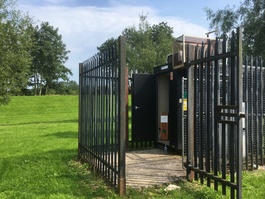
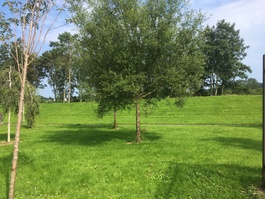
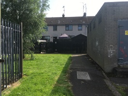
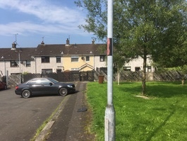
The monitoring station is within a self-contained, air-conditioned housing on Orkney Road at the rear of a housing development off of Old Crebilly Road. The surrounding area is urban residential. The monitoring station is approimately 50 metres West of the M2 motorway.
UK-AIR ID: UKA00503
EU Site ID: GB0934A
Altitude (metres): 59
Environment Type: Urban Background
Site Location
Environment Type: Urban Background
Site Address: Ballymena
Government Region: Northern Ireland
Easting/Northing: 127317, 560150
Latitude/Longitude: 54.861595, -6.250873
The static map below shows where the monitoring site is located.
» View this location on Google Maps (new window)
» View this monitoring site on the interactive monitoring networks map
Partners
The Partners who operate networks at this monitoring sites are shown in the table below. Clicking on the Partner name will open their website in a new window.
| Operator | Networks |
|---|---|
| Bureau Veritas | Automatic Urban Monitoring Network |
| Ricardo Energy & Environment | PAH Digitel (solid phase) |
| National Physical Laboratory | UK Black Carbon Network |
Pollutants measured at this monitoring site
The pollutants measured at this monitoring site, grouped by network, are shown below. Use the links below to quickly jump to a specific network.
Automatic Urban Monitoring Network
| Pollutant | Start Date | End Date | Inlet Height (m) | Hourly PM Measurement method |
|---|---|---|---|---|
| Nitric oxide | 01/05/2016 | - | 2.0 | |
| Nitrogen dioxide | 01/05/2016 | - | 2.0 | |
| Nitrogen oxides as nitrogen dioxide | 01/05/2016 | - | 2.0 | |
| Sulphur dioxide | 01/01/2010 | - | 2.0 | |
| Modelled Wind Direction | 01/08/2010 | - | Not available | |
| Modelled Wind Speed | 01/08/2010 | - | Not available | |
| Modelled Temperature | 01/08/2010 | - | Not available |
PAH Digitel (solid phase)
| Pollutant | Start Date | End Date | Inlet Height (m) |
|---|---|---|---|
| Benzo(a)pyrene | 11/01/2007 | - | 2.0 |
| Benzo(a)anthracene | 11/01/2007 | - | 2.0 |
| Benzo(b)fluoranthene | 01/01/2012 | - | 2.0 |
| Benzo(j)fluoranthene | 01/01/2012 | - | 2.0 |
| Benzo(b+j)fluoranthene | 11/01/2007 | 31/12/2011 | Not available |
| Benzo(k)fluoranthene | 11/01/2007 | - | 2.0 |
| Indeno(1,2,3-cd)pyrene | 11/01/2007 | - | 2.0 |
| Dibenzo(ac)anthracene | 01/01/2012 | - | 2.0 |
| Dibenzo(ah)anthracene | 01/01/2012 | - | 2.0 |
| Dibenzo(ah+ac)anthracene | 11/01/2007 | 31/12/2011 | Not available |
| 5-Methyl Chrysene | 11/01/2007 | - | 2.0 |
| Anthanthrene | 11/01/2007 | - | 2.0 |
| Anthracene | 01/01/2021 | - | 2.0 |
| Benzo(b)naphtho(2,1-d)thiophene | 11/01/2007 | - | 2.0 |
| Benzo(c)phenanthrene | 11/01/2007 | - | 2.0 |
| Benzo(e)pyrene | 11/01/2007 | - | 2.0 |
| Benzo(ghi)perylene | 11/01/2007 | - | 2.0 |
| Cholanthrene | 11/01/2007 | 01/05/2019 | 2.0 |
| Chrysene | 11/01/2007 | - | 2.0 |
| Coronene | 11/01/2007 | - | 2.0 |
| Cyclopenta(c,d)pyrene | 11/01/2007 | - | 2.0 |
| Dibenzo(al)pyrene | 11/01/2007 | - | 2.0 |
| Dibenzo(ae)pyrene | 11/01/2007 | - | 2.0 |
| Dibenzo(ai)pyrene | 11/01/2007 | - | 2.0 |
| Dibenzo(ah)pyrene | 11/01/2007 | - | 2.0 |
| Fluoranthene | 01/01/2021 | - | 2.0 |
| Perylene | 11/01/2007 | - | 2.0 |
| Phenanthrene | 01/01/2021 | - | 2.0 |
| Pyrene | 01/01/2021 | - | 2.0 |
| Retene | 01/01/2021 | - | 2.0 |
UK Black Carbon Network
| Pollutant | Start Date | End Date | Inlet Height (m) |
|---|---|---|---|
| Infra Red Particulate matter (950nm) | 14/11/2019 | - | 3.0 |
| Red Particulate matter (660nm) | 14/11/2019 | - | 3.0 |
| Yellow Particulate matter (590nm) | 14/11/2019 | - | 3.0 |
| Green Particulate matter (520nm) | 14/11/2019 | - | 3.0 |
| Blue Particulate matter (470nm) | 14/11/2019 | - | 3.0 |
| UV Particulate Matter (370nm) | 14/11/2019 | - | 3.0 |
Networks measured at this monitoring site
The listing below shows the networks that this monitoring site belongs to. You can search for sites within these networks by clicking on their name, or use the network information links to find out more about them.
| Network | Search | Further Details | Get Data |
|---|---|---|---|
| Automatic Urban and Rural Monitoring Network (AURN) | Automatic Urban and Rural Monitoring Network (AURN) | About network | Latest pollution summary Current Levels Pre-Formatted Data Files |
| Black Carbon | Black Carbon | About network | Data Selector |
| PAH Digitel (solid phase) | PAH Digitel (solid phase) | About network | PAH data download page |