2 InnovationsAEAT-3133


2.1 Naei 1 km x 1 KM emissions inventories
Considerable work has been undertaken at NETCEN over recent years to improve the spatial resolution of the UK National Atmospheric Emissions Inventory (NAEI). A report (Goodwin et al, 1997) has recently been published which details the Geographical Information System (GIS) methods that have been used to derive 1 km x 1 km grid resolution inventories for the UK. In our earlier mapping work, we used a combination of land cover information and estimates of emissions from the major road network at 5 km x 5 km grid resolution to estimate the local emissions of air pollutants (Stedman et al, 1997b). Land cover and emissions from major roads at a 1 km resolution have been used to derive higher resolution maps for NOx and NO2 for 1994 (Stedman et al, 1997c). The availability of high resolution maps of emissions estimates for the UK means that they can now be used directly to calculate estimates of ambient concentrations, without having to use land cover as a surrogate statistic.

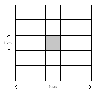
Emissions estimates for 1995 were used in the work presented here. We have derived coefficients for the relationship between ambient air quality and the sum of all low level area and major road sources. We have then used these coefficients to calculate estimated maps. Background air quality is influenced by emissions from an area larger than an individual 1 km x 1 km square. The estimated concentration of a pollutant in each 1 km grid square is, therefore, derived from an estimate of the total of low level emissions from the twenty five 1 km x 1 km grid squares surrounding each location, as illustrated right.

The sum of all low level sources excludes the influence of emissions from Part A processes on local air quality. We have not set out to map the impact of these emissions on local air quality since this would best be addressed using a using dispersion model. The influence of these emissions on regional air quality has been implicitly included in the rural concentration fields which underpin the maps.
2.2 Larger number of automatic monitoring sites
There has been a considerable increase in the availability of automatic monitoring data over the last few years. Data from many more sites are available for 1996 than were available for 1994. Details of the automatic monitoring sites used in the current mapping work can be found in Appendix 1. Data from the DETR Automatic Urban Network (AUN), Rural Monitoring Network (RMN) and Hydrocarbon Network (HC) were used supplemented with data from the Joint Environment Programme of National Power, Eastern Generation and PowerGen (JEP) and the London Air Quality Network (LAQN). Annual means for 1996 were used whenever possible. Annual means for 1995 were used if data for 1996 were not available.

Maps of rural concentrations of NO
2, SO2 and ozone were also required for the mapping and maps of annual mean concentrations for 1995 were the most up to date maps that were available at the time of writing. Details of the measurement networks used to derive these rural maps are given in Appendix 2.

Further information on the DETR air quality monitoring networks can be found in Bower et al (1997); information on the LAQN can be found in Barratt et al (1996) and some information on the JEP monitoring sites can be found in Laxen (1996).


2.3 Benzene and 1,3-Butadiene maps from VOC emissions inventory
In our previous report we used relationships between measured NO
x (oxides of nitrogen, NO + NO2) concentrations and those of benzene and 1,3-butadiene to derive maps of these hydrocarbon species from a map of estimated NOx concentrations. This was equivalent to assuming that the 5 km x 5 km square hydrocarbon emissions were proportional to the NOx emissions. The relationships of the rate of emissions with vehicle speed are, however, very different and the hydrocarbon : NOx ratio would therefore be expected to vary with mean vehicle speed. NOx emissions are greatest (in grams per km) at high speeds but emissions of hydrocarbons are greatest at low speeds. The maps presented in our previous report were, therefore, likely to have overestimated concentrations of benzene and 1,3-butadiene in the vicinity of major roads with fast moving traffic, such as motorways. We have improved the mapping method by deriving relationships between measured benzene and 1,3-butadiene concentrations and volatile organic compounds (VOC) emissions. These relationships have then be used to derive maps of estimated concentrations from the VOC inventory.


2.4 CO map from CO emissions inventory
In our previous report we used relationships between measured NO
x concentrations and those of CO to derive a map of CO from a map of estimated NOx concentrations. This was equivalent to assuming that local CO emissions were proportional to NOx emissions. The map presented in this report was derived from a CO emission inventory. As for hydrocarbons, the variation of emissions with vehicle speed for CO and NOx are very different: NOx emissions are greatest (in grams per km) at high speeds but emissions of CO are greatest at low speeds.The new map therefore, better represents the likely background CO concentrations in urban environments influenced by low-speed traffic.


2.5 Lead map
A map of estimated background lead concentrations for the UK is presented for the first time. This map represents lead concentrations in areas where the predominant source is motor vehicle emissions. Ambient concentrations of lead in areas where concentrations are influenced by local industrial sources could be estimated by addition of the modelled concentration arising from the industrial source to the background level.
INDEX