|
Appendix 1 Diffusion Tube Site Details and Data
|
CONTENTS
|
Table A1.1 |
NO2 Diffusion tube sites (2000) |
|
Table A1.2 |
NO2 Diffusion tube sites (2001) |
|
Table A1.3 |
SO2 Diffusion tube sites (2000 & 2001) |
|
|
|
|
|
|
|
|
|
|
|
|
Table A1.1 NO2 Diffusion Tube
Data for 2000 (page 1 of 2)
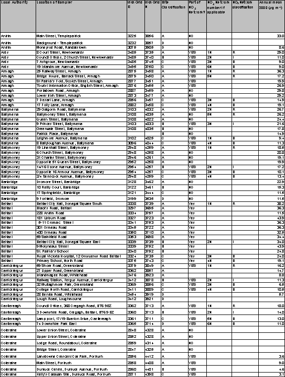
Table A1.1 NO2 Diffusion Tube Data for 2000 –continued; (page
2 of 2)
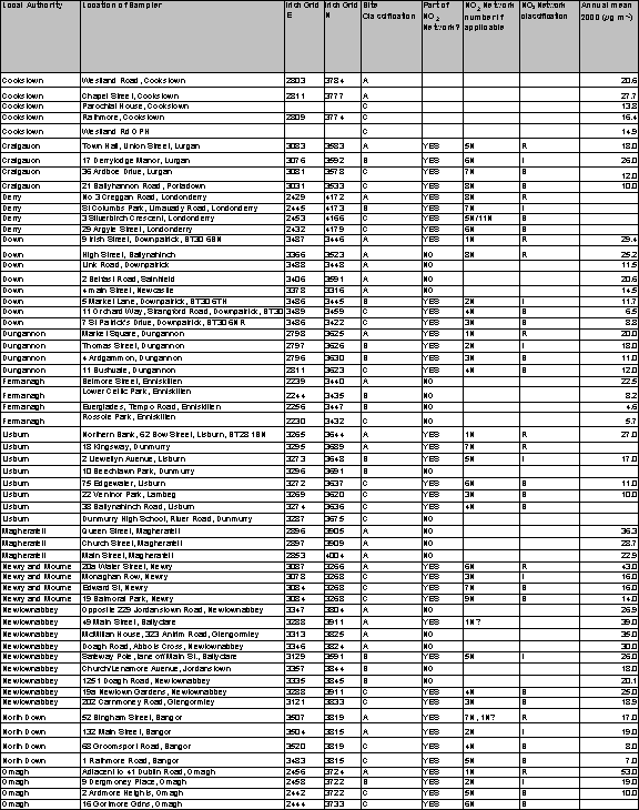
All
grid references are to nearest 100m.
Site classifications:
|
A = kerbside, 1-5m from the kerb of a busy road |
|
B = intermediate site, 20-30m from the same or an
equivalent road |
|
C = urban background site, greater than 50m from
any busy road |
|
D = rural background site |
|
E = special site; monitoring air pollution from
some industrial process, etc. |
Annual means shown only where there are at least 6 months’
valid data.
Table A1.2 NO2 Diffusion Tube Data for 2001
(page 1 of 3)
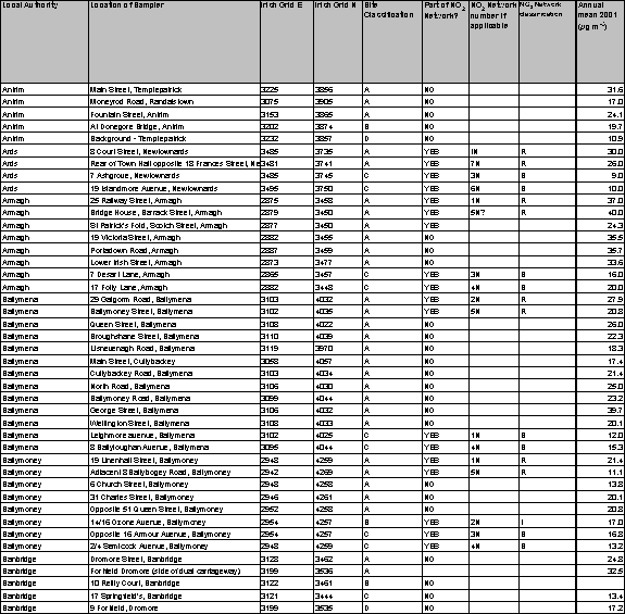
Table A1.2 NO2 Diffusion Tube Data for 2001 – continued; (page 2 of 3)
Table
A1.2 NO2 Diffusion Tube Data for 2001 – continued; (page 3 of
3)
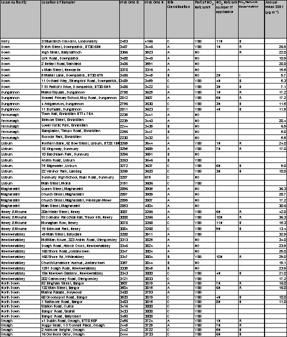
All grid references are to nearest 100m.
Site classifications:
|
A = kerbside, 1-5m from the kerb of a busy road |
|
B = intermediate site, 20-30m from the same or an
equivalent road |
|
C = urban background site, greater than 50m from
any busy road |
|
D = rural background site |
|
E = special site; monitoring air pollution from
some industrial process, etc. |
Annual means shown only where there are at least 6 months’
valid data.
Table
A1.3 SO2 Diffusion Tube Monitoring Sites
|
Site |
District Council |
Easting |
Northing |
|
Town Hall, Carrickfergus |
Carrickfergus |
3415 |
3876 |
|
Lough Road, Loughmourne |
Carrickfergus |
3412 |
3921 |
|
Castleton Park, Portstewart |
Coleraine * |
2382 |
4820 |
|
Lyttlesdale, Garvagh |
Coleraine * |
2859 |
4338 |
|
Drumkil Gdns., Kilrea |
Coleraine * |
2930 |
4326 |
|
30 Daneshill, Coleraine |
Coleraine |
2838 |
4358 |
|
11 Laurel Avenue, Coleraine |
Coleraine |
2832 |
4344 |
|
6/8 Ganimore Avenue, Portrush |
Coleraine |
2897 |
4364 |
|
Queens Avenue, Cookstown |
Cookstown |
2806 |
3789 |
|
Greenvale Drive, Cookstown |
Cookstown |
2806 |
3775 |
|
Tempo Road, Enniskillen |
Fermanagh |
2256 |
3447 |
|
Rossole Park, Enniskillen |
Fermanagh |
2230 |
3431 |
|
Barleyhill, Dunmurry |
Lisburn + |
3272 |
3644 |
|
Ballyknockan Park, Knockmore |
Lisburn + |
3248 |
3639 |
|
22 Ventnor Park, Lisburn |
Lisburn + |
3269 |
3670 |
|
22 Lawnbrook Drive, Low Road, Lisburn |
Lisburn + |
3228 |
3653 |
|
75 Edgewater, Lisburn |
Lisburn + |
3272 |
3637 |
|
36 Credenhill Park, Dunmurry |
Lisburn + |
3285 |
3696 |
|
2 Beattie Park North, Dunmurry |
Lisburn + |
3295 |
3675 |
|
25a Lilac Walk, Seymour Hill, Dunmurry |
Lisburn + |
3292 |
3678 |
|
8 Pine Cross, Seymour Hill, Dunmurry |
Lisburn + |
3286 |
3672 |
|
4 Hornbeam Road, Seymour Hill, Dunmurry |
Lisburn + |
3286 |
3674 |
|
66 Larch Grove, Seymour Hill, Dunmurry |
Lisburn + |
3293 |
3678 |
|
36/38 Elm Corner, Seymour Hill, Dunmurry |
Lisburn + |
3291 |
3678 |
|
Anderson Park, Doagh, Ballyclare |
Newtownabbey |
3263 |
3895 |
|
Ravelston, Carnmoney |
Newtownabbey |
3328 |
3841 |
|
2 Mountainvale Crescent, Glengormley |
Newtownabbey |
3313 |
3823 |
|
15 Carwood Avenue, Glengormley |
Newtownabbey |
3313 |
3835 |
|
57 Burnthill Crescent, Carnmoney |
Newtownabbey |
3317 |
3834 |
|
13 Waverley Road, Newtownabbey |
Newtownabbey |
3322 |
3842 |
|
9 Mountpleasant Road, Jordanstown |
Newtownabbey |
3353 |
3845 |
|
7 Glenbroome Park, Jordanstown |
Newtownabbey |
3361 |
3835 |
|
15/16 Burnside Park, Ballyclare |
Newtownabbey |
3256 |
3918 |
|
22 Osterley Park, Newtownabbey |
Newtownabbey |
3324 |
3825 |
Grid references are in 8-figure format, to nearest 100m
·
* =2000 only, + = 2001 only.
·
All Newtownabbey sites began Dec 2001.