Regional Emission Estimates
Introduction
Extensive work has been conducted to generate reliable emission totals for the Country Regions of the United Kingdom (England, Scotland, Wales and Northern Ireland)[1]. This has been carried out to aid in policy development and monitoring at the regional level. This work has drawn on the UK emission maps presented throughout this report (which give emission on a 1 km x 1 km grid basis). In the following sections, data is given as a total emissions, and as emissions per capita to allow a simple inspection of the similarities and differences of the emissions profiles in each of the countries.
In calculating the emissions by Region, a number of approximations must be made, giving rise to not inconsiderable uncertainties in the resulting emissions totals. For example emissions from the road transport sector in Wales are higher in uncertainty than other regions as additional assumptions are required in generating the data. Pollutants which are dominated by emissions from point sources are expected to be more accurate than those dominated by area sources as the mapping of the point sources is considered to be more reliable.
Regional CO2 Emissions
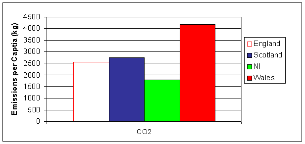
The primary sources of CO2 in the UK are stationary combustion sources and road transport. In Wales, the iron and steel industry combines with a relatively large electricity generating sector (and other industrial activities) to give substantially higher emissions per capita than England or Scotland. Northern Ireland has less of an industrial base, and therefore has a lower CO2 emission per capita than the other countries.
Table 8.1 Emissions of CO2 (as Carbon) by Region
|
|
Unallocated |
England |
Scotland |
Northern Ireland |
Wales |
|
Emissions (Mtonnes carbon) |
10 |
130 |
14 |
3 |
12 |
|
Emissions/Capita (kg/cap) |
|
2,500 |
2,800 |
1,800 |
4,200 |
It should be noted that these calculations have been made on data in a UN/ECE format which differs slightly from the CO2 emissions data given in Chapter 2.
Figure 8.1 Regional Emissions of CO2 (as carbon) per Capita
Regional Emissions of AQS Pollutants
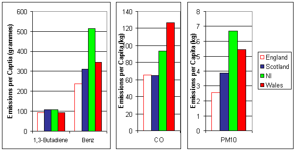
Although Benzo[a]pyrene has been added to the air quality strategy in England, it is presented here separately as a POP.
The emissions of CO are dominated by road transport in all of the regions except for Wales. This is because there are a relatively high number of large point sources located in Wales associated with industrial activities (as mentioned in Section 8.2). The impact on the emission per capita for the Regions is large.
PM10 emissions per capita in Northern Ireland are elevated due to the relatively higher use of solid fuel in domestic heating.
Road transport accounts for some 85-90% of the total 1,3-butadiene emission for all of the regions except Scotland (where the contribution is only 70%). This is because there are a number of significant 1,3-butaidene point sources in Scotland associated with the petroleum industry (see also VOC emissions in Section 8.4). However, the emissions per capita are broadly similar. The emissions for benzene are slightly different in that domestic combustion, rather than industrial emissions, is a significant contribution in Northern Ireland.
Table 8.2 Emissions of AQS Pollutants by Region
|
|
Unallocated |
England |
Scotland |
Northern Ireland |
Wales |
|
1,3-Butadiene |
|
|
|
|
|
|
Emissions (tonnes) |
99 |
4585 |
542 |
177 |
266 |
|
Emissions/Capita (g/cap) |
|
92 |
106 |
105 |
90 |
|
Benzene |
|
|
|
|
|
|
Emissions (tonnes) |
617 |
12235 |
1645 |
894 |
1038 |
|
Emissions/Capita (g/cap) |
|
245 |
322 |
527 |
352 |
|
Carbon Monoxide |
|
|
|
|
|
|
Emissions (ktonnes) |
49 |
3259 |
331 |
157 |
371 |
|
Emissions/Capita (kg/cap) |
|
65 |
65 |
93 |
126 |
|
PM10 |
|
|
|
|
|
|
Emissions (ktonnes) |
5 |
122 |
19 |
11 |
15 |
|
Emissions/Capita (kg/cap) |
|
2 |
4 |
6 |
5 |
Figure 8.2 Regional Emissions of NAQS Pollutants
Regional Emissions of Acidifying Pollutants and Ozone Precursors
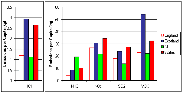
For NOx, the relative contribution from source sectors to the regional total is generally comparable with the exception of industrial point sources. This gives rise to higher emissions per capita for Wales, and lower emissions per capita for Northern Ireland. NOx emissions from road transport account for just under half of the total NOx emissions for all Regions.
SO2 emissions in the UK are generally dominated by point source emissions. There are relatively few significant point sources in Northern Ireland, but a substantial amount of solid fuel is used for domestic heating in Northern Ireland. The net effect is to give an emission per capita that is lower than the other Regions. Emissions per capita in Wales are elevated due to production process point sources.
The most striking difference between the Regions relating to VOC emissions are concerned with point source emissions. The extensive emissions from the petroleum industry in Scotland give rise to a large contribution from point sources, and a considerably larger emission per capita. The emission per capita for Wales is also larger than that for England or Northern Ireland for the same reason. NH3 emissions are dominated by the agricultural sector, and the more distribution of livestock and the population gives higher emissions per capita in Northern Ireland and lower emissions per capita in England.
As HCl emissions arise almost exclusively from coal combustion, the majority of emissions arise from point sources (electricity generation in particular). However in Northern Ireland, as previously highlighted, there are relatively few point sources, and consequently the emissions per capita are smaller than the other Regions. The emissions from England, Scotland and Wales are dominated by electricity generation, and the lower populations in Scotland and Wales gives rise to high emission per capita.
Table 8.3 Emissions of Acidifying Pollutants and O3 Precursors by Region
|
|
Unallocated |
England |
Scotland |
Northern Ireland |
Wales |
|
HCl |
|
|
|
|
|
|
Emissions (ktonnes) |
0 |
59 |
15 |
2 |
8 |
|
Emissions/Capita (kg/cap) |
|
1 |
3 |
1 |
3 |
|
NH3 |
|
|
|
|
|
|
Emissions (ktonnes) |
0 |
211 |
45 |
33 |
30 |
|
Emissions/Capita (kg/cap) |
|
4 |
9 |
19 |
10 |
|
NOx |
|
|
|
|
|
|
Emissions (ktonnes) |
116 |
1142 |
136 |
31 |
87 |
|
Emissions/Capita (kg/cap) |
|
23 |
26 |
18 |
30 |
|
SO2 |
|
|
|
|
|
|
Emissions (ktonnes) |
59 |
883 |
121 |
23 |
79 |
|
Emissions/Capita (kg/cap) |
|
18 |
24 |
13 |
27 |
|
VOC |
|
|
|
|
|
|
Emissions (ktonnes) |
103 |
1158 |
280 |
38 |
96 |
|
Emissions/Capita (kg/cap) |
|
23 |
55 |
23 |
33 |
Figure 8.3 Regional Emissions of Acidifying Pollutants and Ozone Precursors
Regional Emissions of Persistent Organic Pollutants
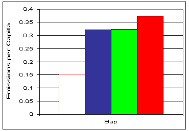
Emissions of BaP arise from a variety of sources, but primarily road transport and domestic combustion of solid fuels. Due to the higher levels of solid fuel combustion in the domestic sector in Northern Ireland, the emissions per capita are higher than other Regions. High concentrations of PAH's have generally been observed at several locations. In Wales the emissions are dominated by industrial point sources, and in Scotland the lower population density gives rise to a higher contribution from road transport and increased use of solid fuel in the domestic sector- both of which enhance the BaP emissions per capita.
Table 8.4 Emissions of POPs by Region
|
|
Unallocated |
England |
Scotland |
Northern Ireland |
Wales |
|
BaP |
|
|
|
|
|
|
Emissions (tonnes) |
0 |
8 |
2 |
1 |
1 |
|
Emissions/Capita (g/cap) |
|
0.15 |
0.32 |
0.32 |
0.37 |
Figure 8.4 Regional Emissions of Persistent Organic Pollutants
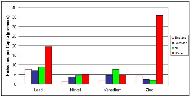
Regional Emissions of Heavy Metals
For heavy metals, the largest sectoral contribution to the total is dependent on the metal. For some, solid fuel combustion in power generation, industry and the domestic sector are important and trends may be observed as explained in previous sectors. For others, the consumption of liquid fuels gives rise to the most significant sources.
Emissions per capita of Arsenic are high due to the increased use of solid fuel in the domestic sector. Emissions per capita of Cadmium, Chromium and Copper are noted to be particularly high in Wales. This is due to the relatively large amount of coal consumed for electricity generation, emissions from the iron and steel industry (both coal consumption and industrial processes), and other industrial activities located in the Region.
Emissions of Lead primarily arise from road transport. However, although production processes account for a small percentage on a UK basis, the emissions are concentrated in Wales, giving rise to higher emission per capita. A similar explanation can be given for zinc emissions, which are associated with the iron and steel industry and other processes.
Vanadium emissions primarily arise from the combustion of petroleum fuels, and the relatively high use of liquid fuels in Northern Ireland give rise to higher emissions per capita.
Table 8.5 Emissions of Heavy Metals by Region
|
|
Unallocated |
England |
Scotland |
Northern Ireland |
Wales |
|
As |
|
|
|
|
|
|
Emissions (tonnes) |
0 |
25 |
3 |
3 |
3 |
|
Emissions/Capita (g/cap) |
|
0.5 |
0.6 |
2.0 |
0.8 |
|
Cd |
|
|
|
|
|
|
Emissions (tonnes) |
0 |
4 |
0 |
0 |
1 |
|
Emissions/Capita (g/cap) |
|
0.1 |
0.1 |
0.1 |
0.3 |
|
Cr |
|
|
|
|
|
|
Emissions (tonnes) |
0 |
54 |
3 |
1 |
4 |
|
Emissions/Capita (g/cap) |
|
1.1 |
0.7 |
0.9 |
1.3 |
|
Cu |
|
|
|
|
|
|
Emissions (tonnes) |
0 |
33 |
3 |
2 |
8 |
|
Emissions/Capita (g/cap) |
|
0.7 |
0.6 |
1.0 |
2.7 |
|
Hg |
|
|
|
|
|
|
Emissions (tonnes) |
0 |
7 |
1 |
0 |
1 |
|
Emissions/Capita (g/cap) |
|
0.1 |
0.1 |
0.2 |
0.2 |
|
Ni |
|
|
|
|
|
|
Emissions (tonnes) |
2 |
72 |
19 |
7 |
15 |
|
Emissions/Capita (g/cap) |
|
1.4 |
3.7 |
4.3 |
5.0 |
|
Pb |
|
|
|
|
|
|
Emissions (tonnes) |
2 |
387 |
35 |
15 |
57 |
|
Emissions/Capita (g/cap) |
|
8 |
7 |
9 |
19 |
|
Se |
|
|
|
|
|
|
Emissions (tonnes) |
0 |
41 |
3 |
1 |
4 |
|
Emissions/Capita (g/cap) |
|
0.8 |
0.6 |
0.8 |
1.3 |
|
V |
|
|
|
|
|
|
Emissions (tonnes) |
5 |
102 |
24 |
13 |
14 |
|
Emissions/Capita (g/cap) |
|
2.0 |
4.6 |
7.6 |
4.7 |
|
Zn |
|
|
|
|
|
|
Emissions (tonnes) |
2 |
213 |
13 |
3 |
105 |
|
Emissions/Capita (g/cap) |
|
4 |
2 |
2 |
36 |
Figure 8.5a Regional Emissions of Heavy Metals
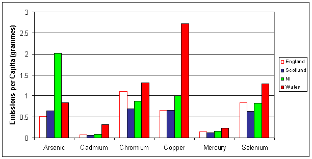
Figure 8.5b Regional Emissions of Heavy Metals
UK Territories and Dependencies
Introduction
There has been an increased focus on emissions from UK territories and dependencies across the last several years. This has been driven by the need to specify emissions from these areas for International reporting requirements, and to allow demonstration of compliance with emission reduction protocols. It has also allowed the generation of emission inventories which will aid in local policy formation.
On an absolute basis, the emissions from the territories and dependencies are very small when compared with the UK (for example the population of Guernsey is some 0.1% of the UK total). However, these territories and dependencies can elect to subscribe to international protocols in their own right. They will therefore have to demonstrate similar percentage emission reductions as the UK and other subscribing countries.
It is often more difficult to obtain the data required for making air emission estimates in these smaller communities. As a result some of the data presented below is in an aggregated format- although the UN/ECE classification used in this report is adopted as extensively as possible.
When compiling or generating emission estimates for the locations in the following sections, the data has been very varied. In some cases emission estimates have already been made, and these have been used to allow consistency with existing "official" datasets. In other cases suitable data is sparse, and the methods have to be simple. It is appreciated that this gives rise to high uncertainties associated with the estimates.
Inclusion/Exclusion in Protocols
The UK has a number of international commitments with respect to air emissions. However, when agreeing to be a signatory to the various international protocols, the precise definition of the individual elements of the UK to be included were also specified.
For example, under the 1979 Geneva Convention on Long-range
Transboundary Air Pollution and the 1988 Sofia Protocol (concerning the Control
of Emissions of Nitrogen Oxides), the "UK" is specified as including the
Bailiwicks of Jersey and Guernsey, the Isle of Man, Gibraltar, and the United
Kingdom Sovereign Base Areas of Akrotiri and Dhekhelia on the Island of Cyprus.
As a result NOx and VOC emission estimates have been (or are being)
generated for these locations. In addition, for other protocols, several
locations are excluded as the "UK" is defined as including the
Bailiwicks of Jersey and Guernsey and the Isle of Man only.
The Bailiwick of Guernsey
Population: 58,681 (1996), approx. 0.1% of UK
Area : 78 km2, approx. 0.03% of UK
The Bailiwick of Guernsey consists of Guernsey and a number of other smaller islands (which are not significant with respect to air emissions). Although an extensive amount of farming is still present in Guernsey, this has declined over recent years along with fishing. Tourism has also declined, leaving financial activities as the dominant sector of the economy.
Compared with the UK mainland, there is very little industry in Guernsey. Ownership and use of private cars is relatively high, and being an island community there are high marine and aircraft activities (on a per capita basis). Electricity has been provided by an oil fired power station, but the recent completion of an undersea electricity cable link from France (via Jersey) is expected to have a significant impact on the use of the power station. A waste to energy is planned to alleviate the pressure on the limited landfill space, which has been used as the main disposal route. There is no mains gas, and therefore the domestic sector uses coal, oil and bottled gas for heating.
Table 8.7a. NOx and NMVOC Emission Estimates for Guernsey1
|
|
|
NOx
|
NMVOC |
|
|
|
tonnes |
tonnes |
|
1 |
Public Power Generation |
608 |
1 |
|
2a |
Residential Combustion |
49 |
108 |
|
2b |
Combustion in Agriculture |
100 |
3 |
|
3 |
Industrial Combustion |
included in Category 2 |
|
|
4 |
Production Processes |
0 |
84 |
|
5 |
Extrac/Distrib. Fossil Fuel |
0 |
179 |
|
6 |
Solvent Use |
0 |
12 |
|
7 |
Road Transport |
396 |
609 |
|
8 |
Other Mobile Sources |
|
|
|
|
Shipping |
128 |
14 |
|
|
Aircraft |
539 |
246 |
|
|
Other Off-Road |
449 |
55 |
|
9 |
Waste Treatment and Disposal |
1 |
0 |
|
10 |
Agriculture |
0 |
0 |
|
11 |
Nature |
0 |
0 |
|
|
TOTAL |
2270 |
1312 |
1 Based on work by Cook (2000).
Whilst the above emission estimates represent the general profile in Guernsey, it is thought probable that the emissions given for road transport are an underestimate. This arises from the methodology employed with the available data. More work will be conducted on this in the near future.
The Bailiwick of Jersey
Population: 87,186 (2001), approx. 0.15% of UK
Area : 116 km2, approx. 0.05% of UK
Similar in profile to Guernsey, although with a higher population, but lower population density. Declines in agriculture, fishing and tourism, with the finance sector becoming increasingly important.
The undersea electricity cable link from France is having a significant impact on the electricity generating profile on the island. Jersey are currently compiling an air quality management strategy. The primary exposure to air pollutants is associated with street canyons and road vehicle emissions.
Table 8.7b. NOx and NMVOC Emission Estimates for Jersey
|
|
|
NOx
|
NMVOC |
|
|
|
tonnes |
tonnes |
|
1 |
Public Power Generation |
849 |
13 |
|
2 |
Residential Combustion |
176 |
61 |
|
3 |
Industrial Combustion |
|
|
|
4 |
Production Processes |
0 |
19 |
|
5 |
Extrac/Distrib. Fossil Fuel |
0 |
130 |
|
6 |
Solvent Use |
0 |
485 |
|
7 |
Road Transport |
1777 |
2022 |
|
8 |
Other Mobile Sources |
|
|
|
|
Shipping |
190 |
21 |
|
|
Aircraft |
148 |
32 |
|
|
Other Off-Road |
1112 |
136 |
|
9 |
Waste Treatment and Disposal |
1 |
1 |
|
10 |
Agriculture |
0 |
0 |
|
11 |
Nature |
0 |
0 |
|
|
TOTAL |
4252 |
2920 |
The methodology employed for estimating emissions from road transport (and Other Off-Road mobile sources) may give rise to overestimates. The high estimates arise due to a significant contribution from goods vehicles. The emission estimates from these vehicles are determined by using fleet data with estimates of annual mileage, i.e. the methodology assumes that all of the registered vehicles are in frequent use. Until further data is available it is only possible to speculate how much a revised figure will differ from the estimates presented in Table 8.7b above. For Other Off-Road mobile sources a similar argument may be used (primarily regarding the use of tractors).
The Isle Of Man
Population: 72,017 (1994), approx. 0.12% of UK
Area : 572 km2, approx. 0.23% of UK
As with the Channel Islands offshore banking dominates over tourism and agriculture. The population density is relatively lower than the Channel Islands, and there is considerably more agricultural land.
Table 8.7c. NOx and NMVOC Emission Estimates for The Isle of Man1
|
|
|
NOx
|
NMVOC |
|
|
|
tonnes |
tonnes |
|
|
Point Sources |
3715 |
1 |
|
|
Residential Combustion |
65 |
308 |
|
|
Road Transport |
688 |
1723 |
|
|
Other Mobile Sources |
223 |
34 |
|
|
Agriculture |
0 |
0 |
|
|
Nature |
0 |
0 |
|
|
TOTAL |
4691 |
2066 |
1 Based on Wilkinson pers. comm.
Data is currently available to a lower level of sectoral disaggregation. However, the apportionment of the emissions across the sectors seems sensible.
Gibraltar
Population: 27,192 (1997), approx. 0.05% of UK
Area : 6.5 km2, <0.01% of UK
Although Gibraltar has a land border with Spain, many of the imports/exports arrive and leave by sea. Much of the land in Gibraltar is not available for building on, being dominated by the famous rock at its centre. As a result the population density is high in areas of housing, although virtually no fuel is used for domestic heating due to the warmer weather. As with the islands above, there is a relatively high marine and aircraft activity, and virtually no industry present in Gibraltar. However, Gibraltar differs in that there is a large military base located at the Southern end of the peninsula. Although the size of the base has significantly reduced over recent years, the activities are a significant fraction of the emissions to air from Gibraltar, and have been incorporated in the emission estimates presented below.
|
|
|
NOx |
NMVOC |
|
|
|
tonnes |
tonnes |
|
1 |
Public Power Generation |
472 |
5 |
|
2 |
Inst, Comm.&Res. Combustion |
0 |
0 |
|
3 |
Industrial Combustion |
93 |
1 |
|
4 |
Production Processes |
0 |
0 |
|
5 |
Extrac/Distrib. Fossil Fuel |
0 |
143 |
|
6 |
Solvent Use |
0 |
372 |
|
7 |
Road Transport |
208 |
415 |
|
8 |
Other Mobile Sources |
|
|
|
|
Shipping |
55 |
6 |
|
|
Aircraft |
37 |
20 |
|
|
Other Off-Road |
69 |
9 |
|
9 |
Waste Treatment and Disposal |
53 |
16 |
|
10 |
Agriculture |
0 |
0 |
|
11 |
Nature |
0 |
0 |
|
|
TOTAL |
986 |
987 |
These emissions were calculated in some detail and are considered to be fairly robust.
Sovereign Bases in Cyprus (Akrotiri and Dhekhelia)
The compilation of emissions estimates from military activities in the two Cyprus sovereign bases are not yet complete. Provisional NOx and NMVOC estimates have been made, but these require additional data before being robust enough for general release. These estimates are expected to be finalised shortly.