Introduction
An Introduction to Emission Inventories
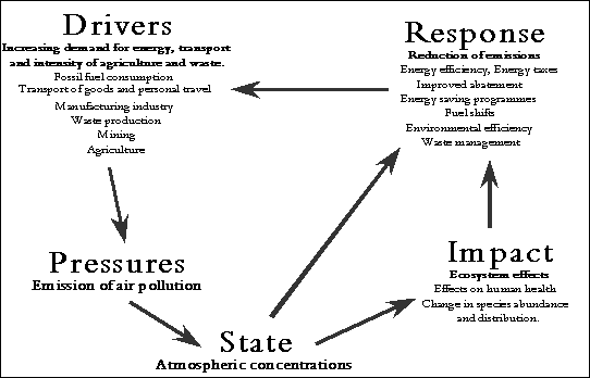
Emission inventories play an important role in assessing the effects of anthropogenic (man‑made) activity on atmospheric pollution. The principal human demands for energy, transportation, materials and food may be regarded as the “drivers” for the production of air pollutants. In order for an economy to continue to develop in a sustainable way these sources of pollution must be managed. To do this we must understand the “impacts”- i.e. what types of pollution affect which parts of the environment or human health, and to what extent. To decide whether action is necessary we also need to know the “state” of the environment- i.e. to evaluate whether the levels in the environment exceed those which will cause environmental harm.
In taking appropriate action we must be able to respond in a focused way to control and reduce pollution while avoiding larger-scale damage to economic development. Emission inventories provide policy makers and the public with an understanding of the key polluting sources or the “pressures”, how these sources have developed with economic growth and how they are likely to contribute to pollution in the future. This understanding is essential for a focused “response” to the problems associated with air pollution and to meet the demands of sustainable development.
Figure 1.1 shows how our understanding of the pressures (through emission inventories) interact with other areas of environmental knowledge such as impact assessment and monitoring (state). Figure 1.1 also clearly shows the relationship between: emission inventories, economic activity and effective environmental policy.
Figure 1.1 “DPSIR” Relational Diagram
The UK National Atmospheric Emissions Inventory
The UK National Atmospheric Emission Inventory (NAEI) is compiled by the National Environmental Technology Centre on behalf of the Department for Environment, Food and Rural Affairs (Defra) Air and Environment Quality (AEQ) Division and the devolved administrations. Related work on greenhouse gas emissions is also conducted for the Global Atmosphere Division of the Department. The NAEI is the standard reference air emissions inventory for the UK and includes emission estimates for a wide range of important pollutants. These include: greenhouse gases, regional pollutants leading to acid deposition and photochemical pollution, persistent organic pollutants and other toxic pollutants such as heavy metals. The full range of pollutants is summarised in Table 1.1. Where possible, estimates are presented for 1970-2000. However, for some pollutants, e.g. ammonia, there is insufficient information to produce a 1970-2000 time series and estimates are presented from 1990-2000.
Emission inventories serve several important functions, as explained in Section 1.1. The following highlight several of the more important uses of the UK NAEI:
1. Provision of Public Information- The data from the NAEI is made available to the public in various forms (see Section 1.2.3). The aim is to make information available in an easily understandable format, informing the public of emissions in their area as well as making national emissions data available. The NAEI is paid for by tax payers money, through the Government, and consequently it is important to maintain a high public profile and accessibility to the work. A copy of this report is available on the internet at http://www.naei.org.uk
2. Development of policy
· Identification of Primary Sources- The NAEI compiles emissions from all possible anthropogenic and natural sources (where information allows). Consequently it is simple to determine which source sectors are the major emitters of individual pollutants.
· Temporal and Spatial Trend Assessment- The NAEI provides information to allow temporal trend analysis as it is compiled annually (from 1970 for most pollutants). UK maps are also generated for several of the pollutants, allowing spatial trends to be assessed.
· Inventory Comparisons- Mapped emission inventories exist for a number of cities across the UK. In some cases the techniques used to compile these emission inventories differ from the NAEI. As a result comparison with the NAEI highlights the potential strengths and weaknesses of the different techniques.
· National Modelling Studies- The NAEI is used in a variety of modelling studies investigating spatial and temporal trends in deposition and concentration of pollutants. Furthermore, it is possible to use the NAEI alone to investigate the impact on emissions of particular future policy scenarios.
· Local Support- Data from the NAEI is frequently used by Local Authorities to support air quality assessments, and aid the generation of local policy.
3. National and International Reporting- The NAEI provides the official air emissions estimates for the UK. National and International reporting requirements are given in more detail in the following Sections.
4. Progress on Complying with National and International Commitments- The annual inventory provides an important assessment tool for policy makers. The inventory is used to monitor progress towards emission limits and ceilings at both the national and international level, and is therefore an important tool in assessing the effectiveness of existing policy measures.
International Commitments
The NAEI provides the UK air emission data for submission to United Nations Economic Commission for Europe (UN/ECE) and the United Nations Framework Convention on Climate Change (UNFCCC). Under the UNFCCC, the UK is committed to developing, publishing and regularly updating national emission inventories of greenhouse gases using reporting guidelines from the Intergovernmental Panel on Climate Change (IPCC). The inventories for both direct greenhouse gases (carbon dioxide, methane, nitrous oxide, hydrofluorocarbons, perfluorocarbons and sulphur hexafluoride) and indirect greenhouse gases (nitrogen oxides, carbon monoxide and non-methane volatile organic compounds) are drawn from the UK NAEI emissions data included in this report. Likewise, NAEI estimates of emissions of nitrogen oxides, carbon monoxide, ammonia, sulphur dioxide, NMVOC, persistent organic pollutants and heavy metals are submitted to UN/ECE under the Convention on Long-Range Transboundary Air Pollution (CLRTAP). NAEI data are also provided to international emission inventory activities such as the EC’s CORINAIR and EUROSTAT inventories. The UK inventory team play an important role in the development of international guidelines by the European Environment Agency and the UN/ECE which aims to achieve a consistent set of good quality inventories for all European countries. More information may be found at the EMEP and UNFCCC websites at:
http://www.emep.int/ and http://www.unfccc.de/
Not all international reporting of emissions are drawn from the UK NAEI. One exception is the EC’s forthcoming EPER (European Pollutant Emissions Register) which arises from the IPPC Directive. The Environment Agency’s Pollution Inventory (PI) will provide data for the EPER for England and Wales.
National Information
The NAEI is a key database used to provide air emissions data to the public, UK Government, the devolved administrations, Local Authorities and private sector organisations. Many of the specific policy uses have been outlined above, but there are a number of other ways in which the data is used. Several are given below:
· A significant amount of time is spent providing detailed emission estimates, output from scenario analysis and supporting information to the Defra and the devolved administrations. This information is required for a wide variety of uses; long-term policy support to specific short-term issues.
· A great deal of information is made available to other organisations working on Defra projects, or projects for the devolved administrations. This ensures a high level of consistency and efficiency.
· Mapped emission inventories for the UK are generated on a on a 1x1km scale. These are frequently used as a starting point for many local emission inventories.
· Emission estimates for point sources and emissions arising from the surrounding area are used in modelling studies as part of Environmental Impact Assessments by developers and their consultants.
· There is a two way exchange of data with Trade Associations. This ensures that the NAEI and the Trade Associations can arrive at emission estimates that are truly representative.
· Point sources and emissions arising from the surrounding area are used in modelling studies as part of Environmental Impact Assessments by developers and their consultants.
· Emission factor data is fed into the UK’s Emission Factor Database for access by Local Authorities.
Table 1.1 Pollutants Covered by the Inventories
Pollutant |
|
Range of
Estimates1 |
Type of
Pollutant2 |
|
Carbon Dioxide |
CO2 |
1970-2000 |
G |
|
Methane |
CH4 |
1970-2000 |
G |
|
Nitrous
Oxide |
N2O |
1990-2000 |
G |
|
Hydrofluorocarbons |
HFC |
1990-2000 |
G |
|
Perfluorocarbons |
PFC |
1990-2000 |
G |
|
Sulphur Hexafluoride |
SF6 |
1990-2000 |
G |
|
Nitrogen Oxides |
NOx (NO2
+ NO) |
1970-2000 |
NAQS, AC, IG, O |
|
Sulphur Dioxide |
SO2 |
1970-2000 |
NAQS, AC, IG |
|
Carbon Monoxide |
CO |
1970-2000 |
NAQS, O |
|
Non-Methane Volatile
Organic Compounds |
NMVOC |
1970-2000 |
NAQS, O, IG |
|
Black Smoke |
BS |
1970-2000 |
NAQS |
|
Particulates < 10 mm |
PM10 |
1970-2000 |
NAQS |
|
Ammonia |
NH3 |
1990-2000 |
AC |
|
Hydrogen Chloride |
HCl |
1970-2000 |
AC |
|
Hydrogen Fluoride |
HF |
1970-2000 |
AC |
|
Lead |
Pb |
1970-2000 |
NAQS, TP |
|
Cadmium |
Cd |
1970-2000 |
TP |
|
Mercury |
Hg |
1970-2000 |
TP |
|
Copper |
Cu |
1970-2000 |
TP |
|
Zinc |
Zn |
1970-2000 |
TP |
|
Nickel |
Ni |
1970-2000 |
TP |
|
Chromium |
Cr |
1970-2000 |
TP |
|
Arsenic |
As |
1970-2000 |
TP |
|
Selenium |
Se |
1970-2000 |
TP |
|
Vanadium |
V |
1970-2000 |
TP |
|
Beryllium |
Be |
2000 |
TP |
|
Manganese |
Mn |
2000 |
TP |
|
Tin |
Sn |
2000 |
TP |
|
Polyaromatic
Hydrocarbons |
PAH |
1990-2000 |
TP |
|
Dioxins and Furans |
PCDD/F |
1990-2000 |
TP |
|
Polychlorinated
Biphenyls |
PCB |
1990-2000 |
TP |
|
Lindane (gamma-HCH) |
HCH |
1990-2000 |
TP |
|
Pentachlorophenol |
PCP |
1990-2000 |
TP |
|
Hexachlorobenzene |
HCB |
1990-2000 |
TP |
|
Short-chain
chlorinated paraffins |
SCCP |
1990-2000 |
TP |
|
Polychlorinated
Napthalenes |
PCN |
NE |
TP |
|
Polybrominated
diphenyl ethers |
PBDE |
SE |
TP |
|
Sodium |
Na |
1990-2000 |
BC |
|
Potassium |
K |
1990-2000 |
BC |
|
Calcium |
Ca |
1990-2000 |
BC |
|
Magnesium |
Mg |
1990-2000 |
BC |
1 An explanation of the
codes used for time series:
SE A “Single Emission” estimate not
attributed to a specific year
NE “Not Estimated” due to lack of
information currently available
2 An explanation of the
codes used for pollutant types:
G Greenhouse gas IG Indirect greenhouse gas
O Ozone precursor AC Acid gas
NAQS National Air Quality Standard/Local Air Quality
Management pollutant
TP Heavy metals and POPs
are generally referred to as “Toxic Pollutants” (although other pollutants also
have toxic properties)
BC Base cation
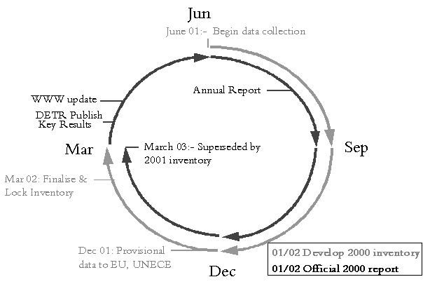
The NAEI is compiled on an annual basis, each year the latest set of data are added to the inventory and the full time series are updated to take account of improved data and any advances in the methodology used to estimate the emissions. Updating the full time series is an important process as it ensures that the entire dataset uses the methodology that is the most current, and hence considered to give the most accurate results and the most accurate indication of temporal trends. The new data are then reported to UN/ECE, UNFCCC and other international fora. This annual cycle of activity is represented schematically in Figure 1.2.
Figure 1.2 The Annual NAEI Cycle
This report presents the definitive 2000 data from the NAEI and is the latest in a series of annual reports published by the NAEI (Eggleston, 1988; Eggleston and Munday, 1989; Munday, 1990; Leech, 1991; Gillham et al 1992; Gillham et al 1994; Salway et al 1996, 1996a, 1997, Salway 2000, Salway et al 2000, Goodwin et al 2000, Goodwin et al 2000, Goodwin et al 2001).
This report discusses trends in pollutant emissions, the accuracy of the emission estimates and in many cases the pattern of their spatial disaggregation within the UK. A detailed description of the methodology used in the compilation of the data is given in Appendix 1 and recent methodological improvements to the inventory, and planned developments are both included in Appendix 2. Mapping methodologies, NMVOC speciation and a full listing of pollutant emissions at a high detail level are also included in the Appendices. The appendices are now not included with this hard copy of the report, but can be accessed from the NAEI webpage (http://www.naei.org.uk).
Information Dissemination
Data from the NAEI is made available to national and international bodies in a number of different formats- as explained in Sections 1.2.1 and 1.2.2. An annual report is produced, giving the most recent emissions data and other information such as: temporal trends, new pollutants and methodology changes. The NAEI team also hold seminars with representatives from industry, trade associations, UK Government and the devolved administrations.
In addition there is a continuous drive to make information available and accessible to the public. A large amount of information is made available on the internet. The NAEI web pages may be found at:
http://www.naei.org.uk
These web pages are arranged into a number of different categories which fall under the following headings:
· Annual Report:- The most recent NAEI annual report is made available in electronic format.
· Methodology:- The methods used for the compilation of the NAEI are given.
· Datasets:- Various datasets are made available, the most comprehensive being a queriable database of the NAEI emission estimates.
· Emissions Maps:- Emissions of pollutants are given in the form of UK maps. These maps give emissions of various pollutants on a 1 x 1 km resolution. It is possible to zoom in to areas of interest, and access the source data for the maps.
· Post Code Search:- This search facility enables visitors to the site to enter their post code, and obtain emissions data concerning the major sources in the vicinity.
The web site is constructed so that the air emissions are placed in context. In addition there are numerous links to locations explaining technical terms, pages giving airborne pollutant concentrations and why there is an interest in particular pollutants. In particular there are links to the various Defra pages containing comprehensive measurement data on ambient concentrations of various pollutants. The main Defra air quality site can be found at http://www.defra.gov.uk/environment/airquality/index.htm.
Continuous Improvement and Basic Methodology
Throughout the compilation of the inventory, considerable effort has been made to ensure both consistency with other national statistics and that all available data sources are considered. Hence, the source data are drawn from a wide range of sources. One source is the provision by the Environment Agency of emissions data, since 1988, on SO2 and NOx emissions from large combustion plant, and more recently the emissions data for Part A Processes in the Pollution Inventory. Where specific point source emission data are unavailable, emissions are estimated from other activity data such as fuel consumption, distance travelled, production or some other statistical data that is directly related to the emissions. Emission estimates are calculated by applying an emission factor to an appropriate activity statistic.
That is:
Emission = Factor × Activity
Emission factors are generally derived from measurements on a number of sources assumed to be representative of a particular source sector. The resulting emission factor may then be applied to similar sources within the sector. However, as mentioned above, some sectors are particularly well characterised and individual point sources within the sector may report a specific emission, which is regarded as being more reliable. This is often the case with sectors incorporating large point sources (an example being the Power Station sector). The inventories presented here are generated using a combination of reported point source emissions, and emissions calculated using emission factors. Methodology improvements are applied to all years (where appropriate).
For many of the pollutants, the major source of emission is generated from fossil fuel combustion. As a result fuel consumption statistics feature prominently in the calculation of these emission estimates. It is important to consider the difference between consumption and deliveries when making use of fuel statistics. Most readily available statistics refer to deliveries which for many source categories relate closely to actual consumption of fuel. However, where fuel can be stockpiled, deliveries and consumption may differ significantly. This is just one example of having to ensure that the available data is correctly interpreted, and used in the most appropriate way to arrive at representative emission estimates.
Emissions from sources such as industrial processes, farm animals and motor fuel evaporation require different statistics; in these cases data on process output, population and motor fuel sales are appropriate.
In other cases, where emissions are more complex, further refinements or an alternative methodology is required. For example, consider the emissions from road vehicles. An obvious activity indicator would be distance travelled, but emissions per unit distance travelled will depend on: vehicle type, vehicle age, engine size, average speed and several other parameters. Clearly the methodology rapidly becomes complicated. A separate road transport model is used for calculating the emissions given in the NAEI.
During 2001, particular emphasis has been placed on improving several areas of the emission inventory. In particular, the uncertainties associated with the emission estimates have been investigated, and emissions for new geographical areas have been estimated.
Under several international protocols, emissions from UK dependent territories (and some other locations) are allotted to the UK. Consequently it has been necessary to estimate the emissions from a number of new geographical locations. Emission estimates for: Gibraltar, Jersey, Guernsey, the Isle of Man have been made, and are included here for the first time. Emissions from two Sovereign base areas of Cyprus are currently being progressed.
At a more general level there is also a continued drive to use data which most accurately represents the source. Emission factors and activity data are assessed each year to identify whether more appropriate information has become available. The methodology used for compiling the inventory is given in Appendix 1, and the most significant changes from the 1999 inventory methodology are given in Appendix 2. The current methodology used for generating emission maps is also included in this report as Appendix 3. It should be noted that this methodology is for mapping only, and does not generate total emission estimates- merely spatially disaggregates them in the most appropriate way. These appendices are no longer included with this hard copy of the report, and can be found on the NAEI website (http://www.naei.org.uk).
Chapters 1 to 7 present the NAEI emission estimates for the UK. They have been divided into five groups, reflecting the national and international activity relating to atmospheric pollution, namely greenhouse gases, National Air Quality Strategy pollutants, stratospheric ozone depletors, acidifying gases and tropospheric ozone and other hazardous air pollutants. Each of these chapters include a discussion of the importance of the pollutants concerned, present time series emission data, and discuss the data trends and the accuracy of the emission estimates. Chapter 8 contains emisisons estimates for the UK, divided into the Country Regions. This allows comparisons to be made on the different industrial profiles in the Regions and the resulting emissions per capita to be considered. The emissions data summarised in this report is available to differing detail levels by accessing the NAEI website (see http://www.naei.org.uk).
Mapping Emissions
The sources contributing to the UK emissions can be represented as one of three categories: points, lines or areas. Sectors such as power stations, refineries and large industrial plant can be represented by points. Their locations are known and data to estimate emission contributions are available. Major roads and railways are sectors that can be represented by lines if data are available. Other diverse and numerous source sectors such as agriculture, domestic and commercial are represented by areas.
The method used to map emissions in the UK is shaped by the data that are available. The technique employs a combination of reported emissions (for emission sources at regulated sites) and surrogate geographical statistics to distribute emissions from line and area sources.
The emission maps combine a number of different source sectors represented by the point, line and area sources. In order to map this combination, the UK is divided into a grid of 1km squares. Emissions are then represented in terms of tonnes per 1km grid square.
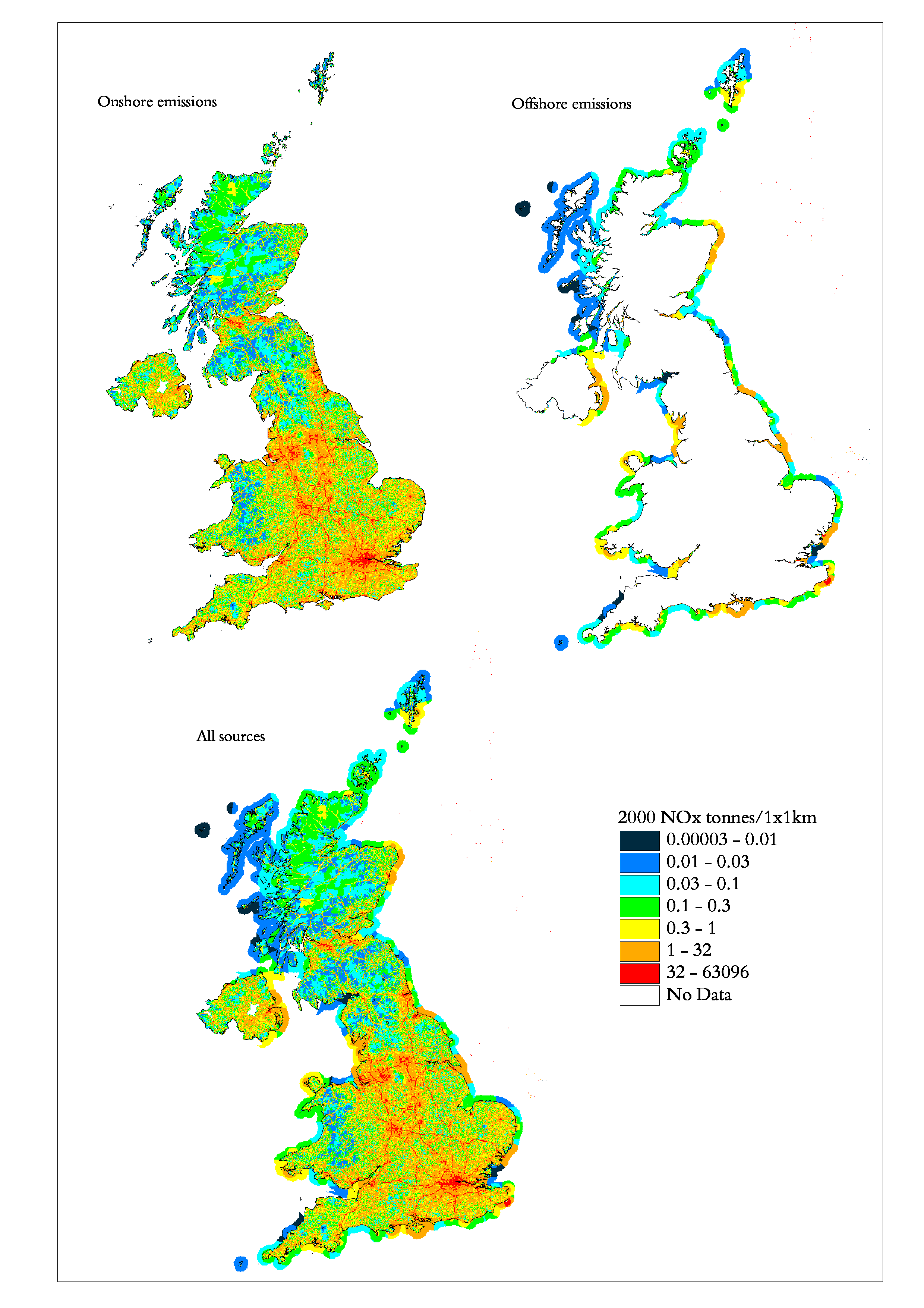
Maps of emissions for various pollutants have been included in the main body of this report. These maps show emissions from all sources including some offshore sources. The offshore component is made up of shipping and fishing related emissions within a 12km coastal zone and also offshore oil and gas extraction further afield. The onshore and offshore components of the maps are shown separately for NOx below in Figure 1.3.
It is difficult to identify an offshore total for many of the pollutants as the emissions occur from a number of different sectors under reporting formats. For example, CH4 emissions from offshore platforms will arise from a number of activities. Emissions may be included under “Extraction and Distribution of Fossil Fuels”, however other emissions may fall within the “Waste Treatment and Disposal” category (e.g. venting of the CH4). Emissions from fuel combustion in shipping fall into the “Other Mobile Sources and Machinery” sector. Annex 1 gives an explanation of the UN/ECE reporting framework and indicates which source category the emissions are reported under.
Figure 1.3 NOx Emissions Maps- Onshore, Offshore and Total Emissions
The Environment Agency’s Pollution Inventory
The Environment Agency (EA) compile a Pollution Inventory (PI) of emissions from around 2,000 major point sources in England and Wales. This requires the extensive compilation of data from a large number of different source sectors. This valuable source of information is incorporated into the NAEI wherever possible, either as emissions data, or surrogate data for particular source sectors. The information held in the PI is also extensively used in the generation of the NAEI maps, as the locations of individual point sources are known. The NAEI and the EA work closely to maximise the exchange of useful information. The PI allows access to air emissions through post code interrogation, and may be found at:-
http://www.environment-agency.gov.uk/