Site Information for Bottesford(UKA00055)
Please Note: This monitoring site is closed.
Bottesford Information
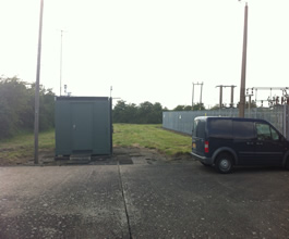
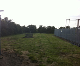
The monitoring station is within a self-contained, air-conditioned housing in a rural setting surrounded by farm land. The nearest main road is the A52 Nottingham to Grantham road, which lies at a distance of approximately 400 metres north of the station. The manifold inlet is approximately 5 metres from the nearest rural road. The surrounding area is open.
UK-AIR ID: UKA00055
EU Site ID: GB0032R
Altitude (metres): 32
Environment Type: Rural Background
Site Location
Environment Type: Rural Background
Site Address: Bottesford
Government Region: East Midlands
Easting/Northing: 479771, 337643
Latitude/Longitude: 52.930280, -0.814722


The static map below shows where the monitoring site is located.
» View this location on Google Maps (new window)
Partners
The Partners who operate networks at this monitoring sites are shown in the table below. Clicking on the Partner name will open their website in a new window.
| Operator | Networks |
|---|---|
| Bureau Veritas | Automatic Rural Monitoring Network |
Pollutants measured at this monitoring site
The pollutants measured at this monitoring site, grouped by network, are shown below. Use the links below to quickly jump to a specific network.
Automatic Rural Monitoring Network
| Pollutant | Start Date | End Date | Inlet Height (m) | Hourly PM Measurement method |
|---|---|---|---|---|
| Ozone | 01/10/1977 | 17/10/2016 | 4.0 | |
| Modelled Wind Direction | 01/08/2010 | 17/10/2016 | Not available | |
| Modelled Wind Speed | 01/08/2010 | 17/10/2016 | Not available | |
| Modelled Temperature | 01/08/2010 | 17/10/2016 | Not available |
UKEAP - Rural NO2 (NO2-Net)
| Pollutant | Start Date | End Date | Inlet Height (m) |
|---|---|---|---|
| Nitrogen dioxide | 01/02/1993 | 24/02/2006 | Not available |
| Nitrogen dioxide as N | 24/06/1991 | 04/01/1993 | Not available |
Weekly rainfall (LOW)
| Pollutant | Start Date | End Date | Inlet Height (m) |
|---|---|---|---|
| Calcium in precipitation | 13/01/1986 | 12/10/2016 | 1.5 |
| Chloride in precipitation | 13/01/1986 | 12/10/2016 | 1.5 |
| Potassium in precipitation | 13/01/1986 | 12/10/2016 | 1.5 |
| Magnesium in precipitation | 13/01/1986 | 12/10/2016 | 1.5 |
| Sodium in precipitation | 13/01/1986 | 12/10/2016 | 1.5 |
| Phosphate as P in precipitation | 13/01/1986 | 12/10/2016 | 1.5 |
| Nitrate as N in precipitation | 13/01/1986 | 12/10/2016 | 1.5 |
| Ammonium as N in precipitation | 13/01/1986 | 12/10/2016 | 1.5 |
| Sulphate as S in precipitation | 13/01/1986 | 12/10/2016 | 1.5 |
| Non-marine sulphate as S in precipitation | 13/01/1986 | 12/10/2016 | 1.5 |
| Acidity in precipitation | 13/01/1986 | 12/10/2016 | 1.5 |
| Conductivity | 13/01/1986 | 12/10/2016 | 1.5 |
| pH in precipitation | 13/01/1986 | 12/10/2016 | 1.5 |
| Rainfall | 13/01/1986 | 12/10/2016 | 1.5 |
| Fluoride | 21/02/2012 | 12/10/2016 | 1.5 |
Networks measured at this monitoring site
The listing below shows the networks that this monitoring site belongs to. You can search for sites within these networks by clicking on their name, or use the network information links to find out more about them.
| Network | Search | Further Details | Get Data |
|---|---|---|---|
| Automatic Urban and Rural Monitoring Network (AURN) | Automatic Urban and Rural Monitoring Network (AURN) | About network | Latest pollution summary Current Levels Pre-Formatted Data Files |
| UKEAP: Historic Aerosol measurements | UKEAP: Historic Aerosol measurements | About network | CEH Website (External website) |
| UKEAP: Precip-Net | UKEAP: Precip-Net | About network | CEH Website (External website) |